The most unique monuments of Haarlemmermeer
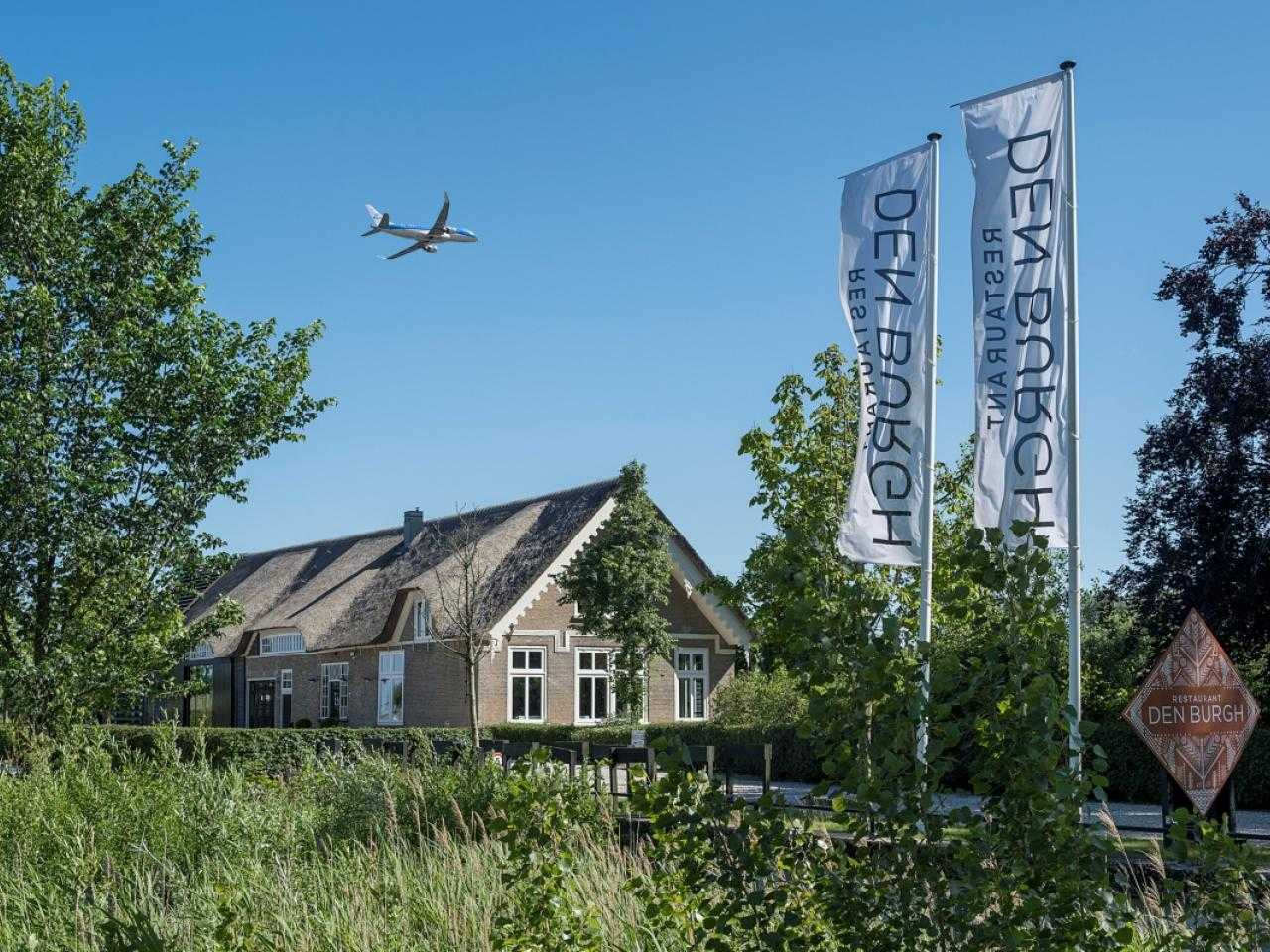
Farm Den Burgh
Farm Den Burgh has a long history. This started in 1855, almost immediately after the reclamation of the Haarlemmermeer. Maria de Vogel van Aalst, lady and widow of a wine merchant, bought a huge piece of land in Haarlemmermeer. She started an arable farm on the land that remained in the family for several generations.
In 1998, the municipality of Haarlemmermeer decided to buy out the last resident in order to keep the farm. The beautiful farm on the estate is still there today. The building is a good example of a Zeeland long-gable farm. In 2013, Stadsherstel renovated the farm and turned it into a beautiful modern version of the original building.
Nowadays you can enjoy a delicious meal in the renovated, monumental farm Restaurant Den Burgh. The restaurant has an open kitchen and a terrace overlooking the Geniedijk. The chefs of the restaurant cook a lot with ingredients from their own vegetable garden and spend a lot of time on the culinary dishes on their menu. This restaurant and monument is definitely worth a visit!
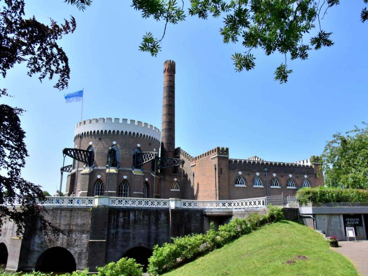
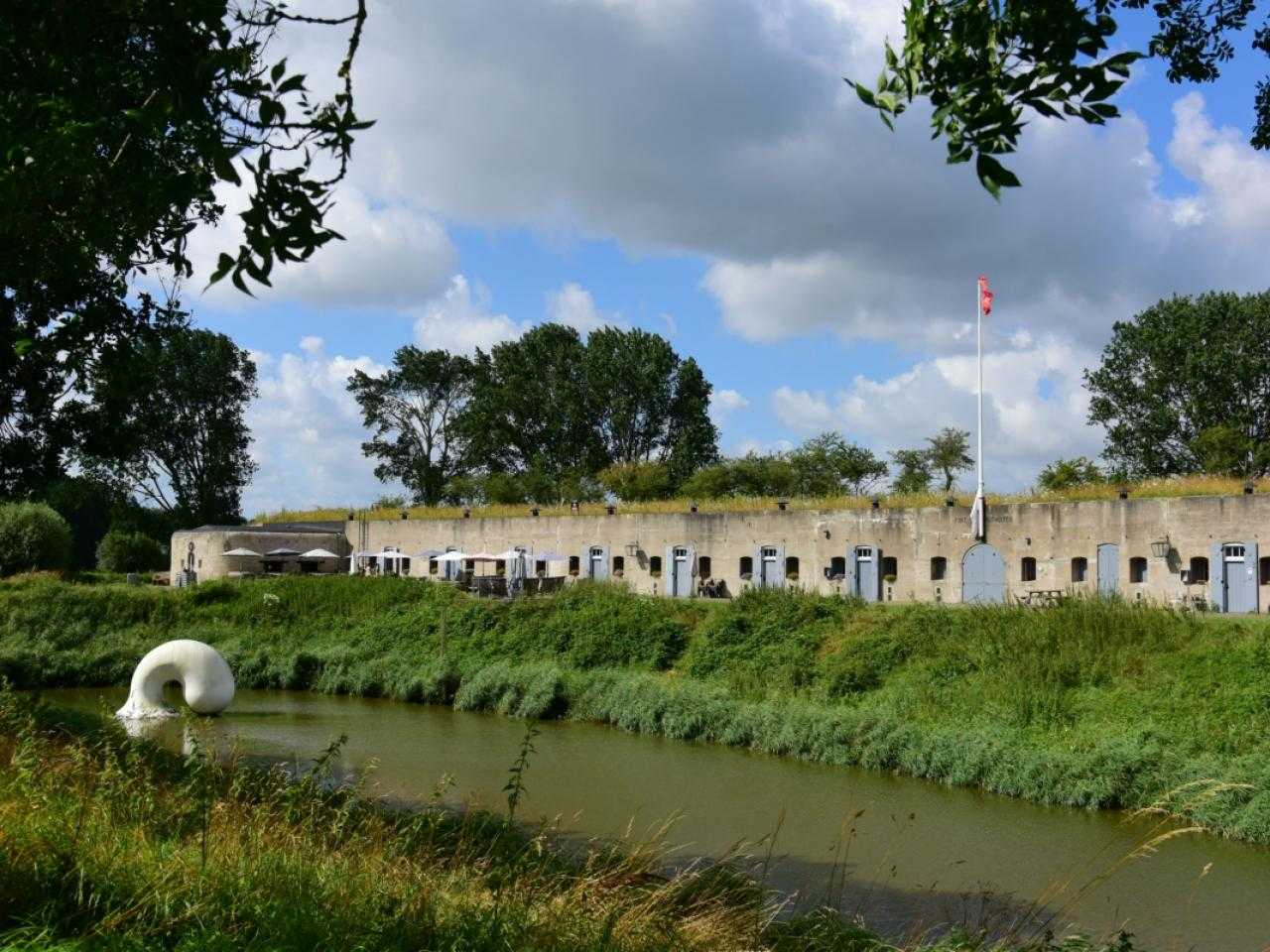
Consort Cruquius
Gemaal Cruquius is an iconic monument that almost everyone in Haarlemmermeer knows. And that is not for nothing, because the pumping station played a major role in the reclamation of the Haarlemmermeer. The pumping station and the surrounding village are named after hydraulic engineer Nicolaus Cruquius. He had grand plans, such as draining the Haarlemmermeer, which were carried out after his death.
Between 1849 and 1852, Cruquius pumping station, Lynden pumping station and Leeghwater pumping station pumped the Haarlemmermeer completely dry. Until 1932, the Cruquius pumping station was still active to ensure that the polder remained dry. Today, Gemaal Cruquius is an impressive museum.
If you go through it Cruquis Museum walk, you get a better picture of how the Haarlemmermeer was drained and what the municipality once looked like. The museum houses the largest steam engine in the world. This one is 100 years old and still works! There is a lot to experience in the museum for young and old, so visit us soon!
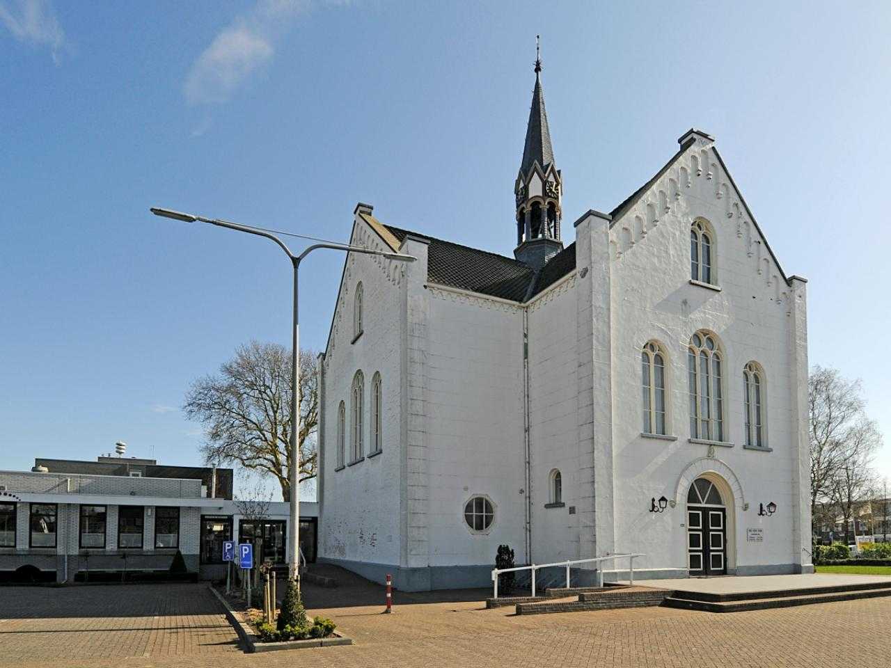
Stompe Toren Cultural Center
The Stompe Toren is a unique monument. It is the oldest monument in Haarlemmermeer! The original building was probably built in 1036. In the 13th century there was a high, pointed tower to which a church building was later attached. in 1537, during the war with the Spaniards, the tower was set on fire. Then only the church walls and the tower remained. A farmer was able to save a few statues and a rosary from the fire. These objects can now be seen in the museum's collection.
After the fire, the church building was restored. However, the enormous history of the church did not end there. The church building was destroyed again by a heavy storm in 1747. In 1764 the church as we can visit it today was built. In 1844 the church could use a makeover again, but there was not much money for that. That is why the 40-meter tower was shortened to just 20 meters. This is how the church got its name: The Stompe Toren.
The last church service was in 1880 and has been administered since 1983 Stompe Toren Cultural Center the building. Nowadays you can visit the monument for various exhibitions, concerts and other cultural activities. It is an impressive monument that you really have to see once.
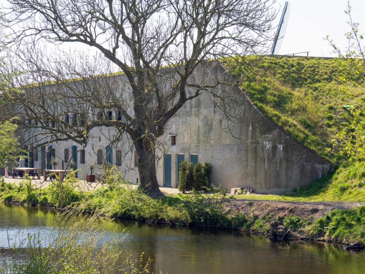
Fort near Vijfhuizen
At Fort bij Vijfhuizen, better known as Kunstfort Vijfhuizen, admire your special art in a unique location. The fort was built in 1897 and was one of the first concrete buildings in the Netherlands. The use of concrete was necessary because the high-explosive shell destroyed a masonry structure. By using concrete, it was certain that the fort would remain standing after an impact from a high-explosive shell.
The fortress is part of the Defense of Amsterdam. This is the 149 km long defense line around the capital that consists of 45 fortresses. The Defense Line of Amsterdam was designed in such a way that it could put the line under a layer of water and thus keep the enemy at a distance. The water was too deep for the army and their horses, but too shallow for ships. The task of the Fort near Vijfhuizen was to defend the ring canal and dike of the Haarlemmermeer polder. Ultimately, the Defense Line of Amsterdam was not necessary due to the invention of airplanes.
Today, visitors can admire art in and around the fort. The art is about climate and politics. Visitors can also enjoy a delicious lunch at restaurant 't Fort. All in all, there is plenty to experience at Kunstfort Vijfhuizen. From art and culture to catering, you will find it all at this monument.
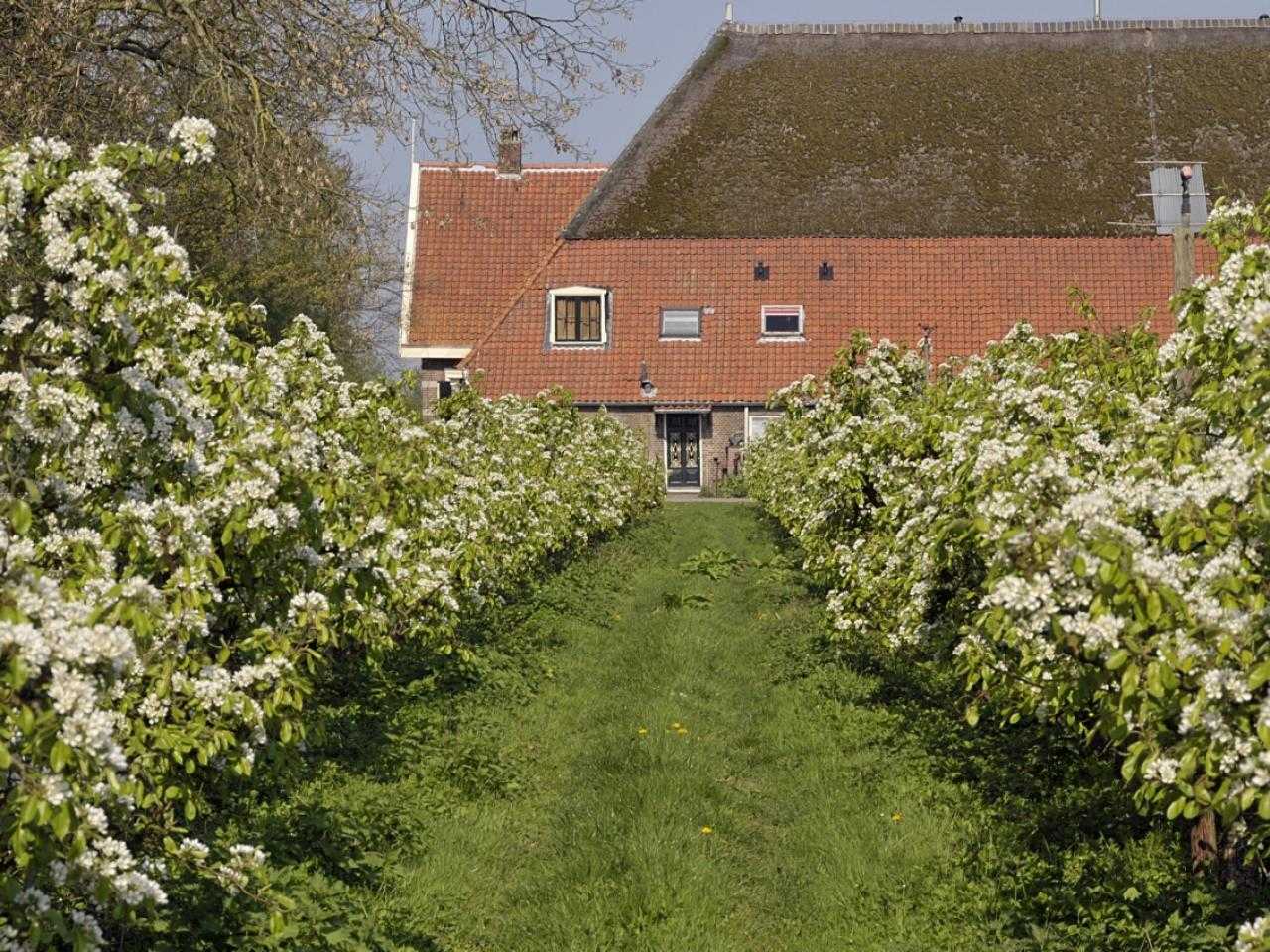
The Olmenhorst
Shortly after the reclamation of the polder, the Amsterdam merchant Stephanus de Clercq started a large arable farm for potatoes, wheat, flax and peas on the estate that we now know as Estate de Olmenhorst. The first farm that was there burned down. The current farm, built in 1894, was located on a strip of elms, also known as elms. That is why the estate was given the name De Olmenhorst. At Landgoed de Olmenhorst there are several buildings that are on the list of municipal monuments, such as the green wooden villa.
The grandson of Stephanus Clerc had the famous wooden villa built in 1906 and settled in the polder as the first generation of owners. Under his leadership, many new orchards were planted and fruit growing became the most important business activity. In the meantime the sixth generation runs the 165-year-old family business. The orchard is huge. There are 50.000 apple trees and 10.000 pear trees!
You can visit this monument all year round. The most beautiful time is spring, when you see blossom all around you. But also in the other seasons there is a lot to see and fun to experience at Landgoed de Olmenhorst. For example, a delicious lunch or catching up with coffee and cake in the Fruit shed. Or juices and jams from the brand De Olmenhorst and fresh harvest shopping in the shop.
De Lynden pumping station
Gemaal Lynden is one of the three steam pumping stations that pumped the Haarlemmermeer dry between 1849 and 1852. The pumping stations then continued to be used to keep the land dry. Consort Lynden is no longer in use. In 2005 it was replaced by a new pumping station next to the old building. This new pumping station has three pumps and a capacity of 1275 m3 per minute. That is more than half more than the old pumping station! The old neo-Gothic steam pumping station has been preserved and is now a national monument.
Small Vennep farm
Klein Vennep is a so-called head-hull farm: the head is the house, the body is the barn. The farm was built in 1928 and is located just outside Nieuw-Vennep on the Hoofdweg. The building, which is a national monument, is located on Landgoed de Kleine Vennep of the same name.
The estate and the accompanying farm have been connected to the family of Boer Dirk Molenaar for three generations. He finds it extremely important that the estate is a place for everyone. Rest, freedom and fun are central. Every year, various events take place at the estate. For example Theater Festival Grazing Swan and the Park21 Summer Weeks. But even if there is no event, you are welcome at the Kleine Vennep. Take a walk, sit on the grass for a picnic or enjoy some sports.
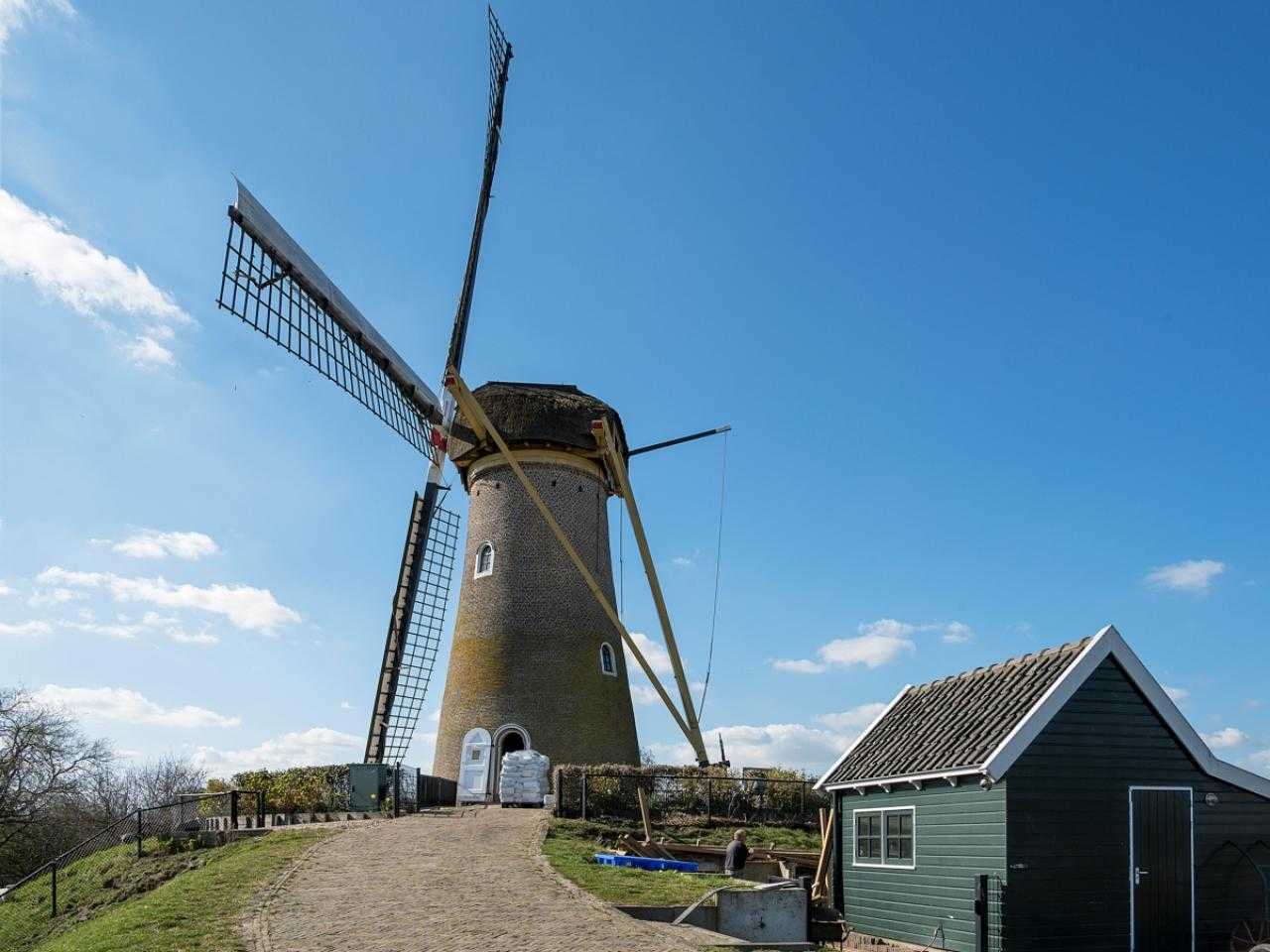
Mill the Firstling
Mill the Firstling is a very unique monument. It is the oldest mill in Haarlemmermeer, the only mill in Haarlemmermeer that is still in operation and it is the first mill in the Netherlands to be moved.
Mill builder Dirk van Dijk built the mill in 1856, shortly after the reclamation of the Haarlemmermeer. From 1954, the milling was motorized and due to the advancing buildings in the area, the mill caught less and less wind. The stationary mill fell into disrepair. That is why the hood and the blades were removed in 1975. In the end it was decided to move and restore the stone mill. On January 4, 1977, the 100.000-kilogram mill was moved to its current location, 1.8 kilometers away. At the new location, the mill received a new hood, tail and blades. Later the miller's house was also moved.
The foundation Cultural Heritage Korenmolen De Eersteling manages the mill shop and maintains the yard and the animals. Drop by sometime to look at the animals or in the monument. Feel like baking? Buy the freshly ground flour directly from the miller!
The White Church
This Dutch Reformed church, now a municipal monument, was inaugurated in 1863 as the first church in Nieuw-Vennep. This makes it not only the oldest church, but also one of the oldest buildings in Nieuw-Vennep. The building is virtually the only remnant from that period and iconic for the center of New Vennep. Church services are still held today! Take a look around or in the church and then settle down at Orries across the street for a snack and a drink.
Fortress of Hoofddorp
The Fort at Hoofddorp Just like Kunstfort Vijfhuizen, it is part of the Defense Line of Amsterdam. This fort also has a long history. This specific fort was supposed to guard the locks and dams needed to flood the land. The fort has never functioned as a defensive structure. The rise of the air force made this defense strategy obsolete. Well stayed soldiers in World War I and became the fortress in the Second World War by used by the Germans.
Since 2020, the fortress has reopened after a major renovation. Many authentic details have been preserved stayed, but there is also substantial invested in sustainability. On the island there is plenty to experience. That way it will be fun cultural activities organized like performances in the open-air theater and exhibitions in the former rooms and casemate. In addition, you can in rrestaurant Fort NOXX good food and drinks. You can visit this monument every day and every first Saturday of the month you can join a guided tour of the island.
Curious about an overview of all monuments (and outdoor works of art) in our municipality? You can find this on the interactive Art and Monuments Map!
Check out the monuments in your core
Farm Andreas Hoeve
- Year of make: 1864
- Address: Hoofdweg 1741
- Type: National monument
- Description: The Andreas Hoeve is a so-called longhouse farm. The farmhouse, built in a traditional traditional style, dates from 1864. A longhouse farm is a farm where the main house and the rear house are an extension of each other under one roof. An example was the old Frisian longhouse, a historic farm type that occurred in North Holland, Friesland, Groningen and the German coastal area.
Meerhof Farm
- Year of make: 1893
- Address: Hoofdweg 1695
- Type: Municipal monument
- Description: The main shape of this head-neck-trunk farmhouse has remained unchanged since its construction in 1893. The facade layout is balanced with carved bargeboards and decoration under the ridge. The door still has the original cast iron decoration. The window openings are intact. The business part is much younger than the residential part. The farm is a good example of a typical Haarlemmermeer arable farm.
Complex: Vondel's Landleeuw Farm
- Year of make: 1935
- Address: Hoofdweg Oostzijde 1666
- Type: National monument
- Description: Vondel's Landleeuw is a special farm complex in Abbenes that has been designated as a national monument. The entire farm complex consists of a house with stables, granary, cart shed and entrance gate. The buildings are arranged in a U-shape around a courtyard. The style is traditionalist brick construction. Such a large-scale design is characteristic of many agricultural companies from the period 1850-1940 in the Haarlemmermeerpolder. The name 'Vondel's Landleeuw' refers to the poem 'Aen den Leeuw van Hollant' in which Joost van den Vondel expresses his support for proposals for "the grinding out of 't Haerlemmer meer" in 1641. In the poem the water is depicted as a wolf and Holland as a lion.
Grave of Dr. Jan Pieter Heije
- Year of make: 1876
- Address: Doctor Heijelaan 80
- Type: Municipal monument
- Description: The grave monument and the adjacent cemetery are a good example of the 19th century funerary style. Characteristically, the cemetery was also intended as a relaxing environment where people could walk. Physician and poet Jan Pieter Heije (1809 – 1876) played an important role in the southern tip of Haarlemmermeer. He regularly stayed in Abbenes where his father-in-law owned a farm. In 1865 permission was requested to build a family grave there. He donated 0,3 hectares of land to the Reformed community of Abbenes. The grave monument itself was paid for by Dutch schoolchildren. The grave monument was designed by Willem Molkenboer (1844 - 1915) and made of bluestone.
Agricultural shed (Complex Vondel's Landleeuw)
- Year of make: 1935
- Address: Hoofdweg Oostzijde 1666
- Type: National monument
- Description: Vondel's Landleeuw is a special farm complex in Abbenes that has been designated as a national monument. The agricultural barn is built on a rectangular floor plan and has a wolfed gable roof with ceramic pirons on the ridge corners.
Dutch Reformed Church
- Year of make: 1868
- Address: Hoofdweg Oostzijde 1764
- Type: Municipal monument
- Description: This hall church and the associated towers are iconic for Abbenes. The building has a balanced architecture and is still in its original state. The basic shape is rectangular with an attached vestry room on the east side. A rose window in the front facade and a half halo above the door. The bell tower rests on the roof and on two corbels in the facade. The land on which the church was built was built by J.P. Heye donated to the village. The first stone was laid by his daughter Cornelia Sophia on July 8, 1868. The church is slightly higher than the rest of the village because it was built on a former island.
Entrance gate (Complex Vondel's Landleeuw)
- Year of make: 1935
- Address: Hoofdweg Oostzijde 1666
- Type: National monument
- Description: Vondel's Landleeuw is a special farm complex in Abbenes that has been designated as a national monument. The entrance gate consists of two brick pillars with bluestone covering plates on which the name of the farm is carved.
Carriage shed (Complex Vondel's Landleeuw)
- Year of make: 1935
- Address: Hoofdweg Oostzijde 1666
- Type: National monument
- Description: Vondel's Landleeuw is a special farm complex in Abbenes that has been designated as a national monument. The carriage shed consists of one floor with a hipped roof. In the middle section there are six wagon sheds with double-hung doors.
Residential house (Complex Vondel's Landleeuw)
- Year of make: 1935
- Address: Main Road East Side
- Type: National monument
- Description: Vondel's Landleeuw is a special farm complex in Abbenes that has been designated as a national monument. The house was built perpendicular to the Hoofdweg. The name “VONDEL'S LANDLEEUW” is printed on the facade. The name 'Vondel's Landleeuw' refers to the poem 'Aen den Leeuw van Hollant' in which Joost van den Vondel expresses his support for proposals for "the grinding out of 't Haerlemmer meer" in 1641. In the poem the water is depicted as a wolf and Holland as a lion.
Farm
- Year of construction: unknown
- Address: Sloterweg 349
- Type: Municipal monument
- Description: Farmhouse of the long facade type. The continuous gable roof has a wolf end at the back and is covered with gray old Dutch tiles. The front facade is divided with three six-pane windows. The windows are placed remarkably high in the facade, as a result of a cellar built under the front house. Both the age of this farm and the rarity of the long facade type are reasons for its monumental status.
Milkhouse
- Year of make: 1991
- Address: Toevluchtstraat 17
- Type: Municipal monument
- Description: The Amsterdam lawyer J.P. van Amersfoordt built De Badhoeve farm on this site in 1854. Van Amersfoordt was a progressive entrepreneur and turned his company into a model farm where he used and demonstrated new agricultural methods. As mayor of Haarlemmermeer (1863 – 1869), Van Amersfoordt was very committed to the economic development of the polder and the health of its residents. De Badhoeve Farm was demolished in 1904, after which a simple farmhouse was built on the same site. The farmhouse and outbuildings, including the churning house, were demolished in the 1980s. In addition to the new residential apartments, a replica of the churn house was built in 1991 with the name 'Badhoeve'. Van Amersfoordt named his farm after the nearby beach Badhoeve on the Haarlemmermeer where Amsterdam residents liked to swim until the reclamation. The dairy house is not only a reminder of the 'De Badhoeve' estate, where Van Amersfoordt was the first to combine livestock farming with arable farming, but also of the name from which the municipality of Badhoevedorp emerged.
Oranje Nassauschool
- Year of make: 1931
- Address: Burgemeester Amersfoordtlaan 61
- Type: Municipal monument
- Description: The Oranje Nassau School was built in 1931 in the style of the Amsterdam School. A number of young Amsterdam architects designed this architectural style, which is mainly found in Amsterdam and the surrounding area. This style has also become increasingly famous internationally. In Haarlemmermeer, the Oranje Nassau School is one of the few buildings with this architectural style in its original state. Characteristics of the architectural style in this building are: the use of bricks and their decoration. The windows where one frame is divided into small rectangular windows. And the facade in which many horizontal lines can be discovered. The Oranje Nassauschool was the winner of the title Haarlemmermeers Monument of the year 2021.
Rehoboth Church
- Year of make: 1921
- Address: Nieuwemeerdijk
- Type: Municipal monument
- Description: In 1921 a permit was granted for the construction of a Sunday school on this site and in 1928 for the construction of a club room. The building was possibly used by the Dutch Reformed Rehoboth Church, which was located in the building until 1973. The building was then used as a community center. Churches were mainly built in the villages. The building is a rare example of a church on the Ringdijk. Characteristic of a church building from the early 20th century are the round-arched windows and the rose window in the point of the facade.
Rietveldschool
- Year of make: 1958
- Address: Edisonstraat 3
- Type: Municipal monument
- Description: In 1958, Rietveld was commissioned to make a design for the Second Public Primary School in Badhoevedorp. The school was completed in 1963. After the architect's death in 1964, in consultation with the Rietveld family, it was decided to name the school after him. The G.Th. Rietveld School is a restrained design by Gerrit Rietveld. Rietveld's hand is clearly recognizable in the design of the school. Particularly thanks to the balanced proportions that are best expressed in the facades and the careful detailing. In 1997, an extensive renovation took place in which architectural parts of the building were adapted to the requirements of the time, with care being taken to preserve the architecture. The renovation was led by architect B. Mulder, a former employee and friend of Rietveld.
Van Amersfoordtschool
- Year of make: 1940
- Address: Roerdompstraat 10
- Type: Municipal monument
- Description: The school building is located in the Vogelbuurt, an expansion district from the 1893s and designed in the garden village concept. Both the urban development plan and the design for the school are by Wieger Bruin (1971 - 1900). The Vogelbuurt was largely built up in the 1950s and is still largely intact. The school is an important urban development element for the neighborhood, located at an intersection of roads, spaciously designed with a playground and associated school garden and the striking chimney that towers above the other buildings. The design stems from the early twentieth-century innovative idea that education and aesthetics should be intertwined. The school building is a typical corridor school with the classrooms facing south-west and south-east and the corridor facing north. The corridor school was the symbol of progress and had become the standard in the period 1950 - 1941. In 31, the school building was expanded on the right side with two more classrooms, creating a T-shaped floor plan. The school building has characteristics of business expressionism, which is recognizable by, for example, the brick architecture, the trapezoid shapes at the entrance, the large roof overhangs, sloping roofs, horizontal lines and the sleek extruded bricks with a deepened and sloping joint for a beautiful shadow effect. In 1944 the school building was requisitioned by the German Armed Forces and on July XNUMX, XNUMX the school building was released again.
Pump building
- Year of make: 1927
- Address: Schipholweg 815
- Type: Municipal monument
- Description: The pump building is designed in Amsterdam School style, recognizable by the use of brick and the non-symmetrical extensions on either side. The windows have steel frames with rod divisions. You can see the coat of arms of Amsterdam in the front gable, as well as in the wrought iron entrance gate. The mirror glass in the concrete frames on the road side has been replaced by glass building blocks. The pump building is in use as a pumping station for Waternet (formerly Gemeentewaterleidingen Amsterdam).
Johannes Evangelist church and parsonage
- Year of make: 1930
- Address: Hoofdweg 2030a and 2032
- Type: municipal monument
- Description: Roman Catholic church building from 1930. Designed by architects Kees Barnholm and Theo van der Eerden in the style of the Amsterdam School. The church is built in the shape of a Roman cross. At the crossing (roof crossing) there is a roof turret (tower) made of copper and slate. Buttresses support the long side walls. The facade is made of masonry in chain bond of brick in Waal format. Stained glass windows in steel frames in the vertical facade openings. The inventory of the church dates from the construction period. The church was built as a subsidiary church of the parish in Lisse-Sassenheim for the Catholics from Buitenkaag (which was called Leeghwaterdorp until the 1960s) and the surrounding area.
Gantry crane
- Year of construction: 1970/1998
- Address: Bennebroekerdijk 219
- Type: Municipal monument
- Description: The blue steel gantry crane was used for the transshipment of raw materials for the production of concrete. The original crane was erected during the construction of the De Cruquius concrete factory, which was established on the Bennebroekerdijk in 1970. The gantry crane was replaced by a replica in 1998. The gantry crane runs on rails along the banks of the Ringvaart, from the construction company site over the road and partly over the water. The crane is valuable as a reminder of the activity along the Ringdijk.
Circle Act farm
- Year of construction: after 1914
- Address: Cruquiusdijk 120
- Type: Provincial monument
- Description: The Kringenwetboerderij is part of the Defense Line of Amsterdam, the 135 km long defense line around the capital. The Dutch circle line was unique in that it would stop the enemy by flooding the country. Farm with a modest house according to the regulations of the Circle Act of 1853. That law stipulated that the field of fire around fortifications had to remain clear. With permission it was possible to build, but with wood so that the object could be removed quickly. The Kringenwet farm was built within 300 meters of the Performance at Vijfhuizen, after permission from the Minister of War. The farm was demolished in 1995 - 1997 and rebuilt in the same form.
Consort Cruquius
- Year of make: 1847-1849
- Architect: Jan Anne Beijerinck
- Address: Cruquiusdijk 27
- Type: National monument
- Description: Cruquius pumping station is one of three steam pumping stations that pumped the Haarlemmermeer dry between 1849 and 1852. The pumping station remained in use until 1932 to keep the polder dry. Of the three pumping stations, Cruquius has largely been preserved in its original state and has been converted into a museum. Engineer Jan Anne Beijerinck (3 - 1800) was from 1874 both manager of the reclamation and designer of the 1837 steam pumping stations. The pumping station has many neo-Gothic elements such as battlements, buttresses, pointed arches with ornamented tracery (outside) and decorated cast-iron stairs and pillars (inside). The design and parts of the steam engine come from England. Cruquius pumping station and the village are named after the hydraulic engineer Nicolaus Cruquius (née Kruik). As supervisor of the Rijnland water board, he moved into the communal house in Spaarndam in 3. Many of his hydraulic engineering plans were implemented after his death, such as the Nieuwe Waterweg and the reclamation of the Haarlemmermeer.
Cruquiushoeve farm
- Year of construction: unknown
- Address: Cruquiusdijk 54
- Type: Municipal monument
- Description: The complex consists of a house, cowshed and milk house and horse stable. The house has a rectangular floor plan and consists of one floor with an attic with a hipped roof above it. It has a symmetrically arranged front facade with a door with two sliding windows on either side. At the separation of the facade and roof you will see a frieze and a profiled gutter molding. The circular floor plan of the former cowshed is very special. The circular facade is made of Waal format brick. The thatched roof is conical. The building is connected to the house and the milk house. What is striking about the milk house are the semi-circular windows in the two gable ends, both covered with stained glass with the pattern of a peacock's tail. The former horse stable is against the side of the milk house.
Fort near Heemstede
- Year of make: 1843-1846
- Address: Spaarneweg 29
- Type: Provincial monument
- Description: The Fort at Heemstede is part of the Defense Line of Amsterdam, the 135 km long defense line around the capital. The Dutch circle line was unique in that it would stop the enemy by flooding the country. The Fort at Heemstede (later Voorposition Cruquius) was constructed as a defense structure. After the reclamation of the Haarlemmermeer, it had to protect Amsterdam with 4 other forts against an attack from the south. This previous line of defense was called the Posten van Kraijenhoff. The other forts are Fort aan de Liede, Fort aan het Schiphol and Fort aan Het Nieuwe Meer. After 1880 they were part of the Defense Line of Amsterdam. Only the foundation of the Fort at Heemstede was built, the building itself was never completed due to a lack of money.
Residential building
- Year of make: 1928-1929
- Architects: P. van Geldorp and Wieger Bruin
- Address: Liedeweg 41
- Type: Municipal monument
- Description: The house is part of a series of characteristic houses on either side of the dike. The houses Liedeweg 41 - 47 were designed and built in the traditional traditional style of construction in the years 1928 - 1931 by the local contractor P. van Geldorp. The permit for the construction of this house was rejected by the Advisory Committee of the North Holland Municipalities for building designs and expansion plans. A combined design by Van Geldorp and architect Wieger Bruin of the advisory committee was approved. The building is constructed in dark red brick. At the height of the window sills, the parapet is finished with a layer of green and brown glazed profile stones.
Residential building
- Year of make: 1928-1930
- Architects: P. van Geldorp
- Address: Liedeweg 43
- Type: Municipal monument
- Description: The house is part of a series of characteristic houses on either side of the dike. The houses Liedeweg 41 - 47 were designed and built in the traditional traditional style of construction in the years 1928 - 1931 by the local contractor P. van Geldorp. The building is constructed in dark red brick. At the height of the window sills, the parapet is finished with a layer of brown-glazed profiled stones. There is a facade stone in the gable on which the name CORRIE* is written in raised capitals. Corrie is the first name of the resident who came to live here at the age of four when her father had the house built and her name added to the facade.
Residential building
- Year of make: 1930-1931
- Architects: P. van Geldorp
- Address: Liedeweg 45-47
- Type: Municipal monument
- Description: Liedeweg 45 - 47 is a one-storey double house under a composite roof. The building is part of a series of characteristic houses on either side of the dike. The houses Liedeweg 41 - 47 were designed and built in the traditional traditional style of construction in the years 1928 - 1931 by the local contractor P. van Geldorp. The building is constructed in dark red brick. The front facade consists of a single-storey part of number 47 and a part with a truncated top facade of number 45. The layout of the front facade is mirrored between the two houses on the ground floor. The top and side lights have a stained glass filling with a geometric motif in clear, yellow and red cathedral glass. A single continuous canopy with wooden paneling has been installed above the doors.
Parish of St. James the Greater
- Year of make: 1837
- Architect: Hermanus Hendrik Dansdorp
- Address: Liedeweg 52
- Type: Municipal monument
- Description: The parish of St. James the Greater is a Catholic church. Before the French Revolution, Catholics were not allowed to openly practice their faith. That is why there was a secret church in the shape of a barn on this site in the 17th and 18th centuries. This church was built in 1837. The church is a so-called 'Waterstaatskerk', a type of church that was built according to a design by engineers from Rijkswaterstaat, and often with financial support from Rijkswaterstaat. This church was designed in neoclassical style by HH Dansdorp. In 1864 the church was enlarged with one window length and a tower, and in 1883 with one bay and a new choir. During the Second World War, the tower and the clock were removed by German soldiers. The tower was replaced in 1954 and a new clock was also installed.
Horse wall
- Year of construction: unknown
- Address: Liedeweg 63
- Type: Municipal monument
- Description: The horse wall is opposite the Parish of St. James the Greater. In the past, the horses of churchgoers were tied to the iron rings in the wall. In 1887 reference was made to a wooden fence at this location. The original stone wall was demolished and reconstructed in 2002.
Fort near the Liebrug
- Year of make: 1886-1900
- Address: Liedeweg 9
- Type: Provincial monument
- Description: Fort near the Liebrug is part of the Defense Line of Amsterdam, the 135 km long defense line around the capital. The Dutch circle line was unique in that it would stop the enemy by flooding the country. Between Amsterdam and Haarlem the railway, the canal and the road intersected the Geniedijk. Fort near the Liebrug had to close both accesses in time of war. The fort offered sleeping places for 159 troops. Unlike the other forts, Fort near the Liebrug does not have a moat but is built in the river Liede. Between the Fort at the Liebrug and the Fort at the Liede there is a remnant of an earthen line wall that used to connect the three forts of the Position at the Liede. Both the fort and the warehouse were restored in 2019.
Engineer warehouse (at Fort bij de Liebrug)
- Year of construction: unknown
- Address: Liedeweg 5a
- Type: Provincial monument
- Description: The engineering shed is located on the grounds of the Fort near the Liebrug. The wooden construction stands on a brick foot wall and is covered by a gable roof with red roof tiles. The warehouse was converted into living space on the south side in 1960, with the number and position of doors and windows changed, as well as the interior layout. The Fort and the warehouse were restored in 2019. The Fort and the warehouse are part of the Defense Line of Amsterdam, the 135 km long defense line around the capital. The Dutch circle line was unique in that it would stop the enemy by flooding the country.
Line wall and secondary battery Liebrug - Liede
- Year of make: 1895
- Address: near Liedeweg/Haarlemmerstraatweg
- Type: Provincial monument
- Description: A line wall was erected between Fort aan de Liebrug and Fort De Liede, containing a secondary battery. Both are part of the Defense Line of Amsterdam, the 135 km long defense line around the capital. The Dutch circle line was unique in that it would stop the enemy by flooding the country. The Position at the Liede consisted of three forts relatively close together. The irregular course of the Liede, the limited flooding capacity and the dense development of waterways, railway lines and roads required a strong defense here. The part of the earth wall with secondary battery remains along the KM Rooselaantje.
Two inundation works
- Year of construction: unknown
- Address: near Penningsveer
- Type: Provincial monument
- Description: These two inlet locks are located on either side of an island in the Binnenliede. The locks made it possible to flood the Waarderpolder and Veerpolder and thus prevent or delay an enemy attack. Fort near Penningsveer provided cover for the work. Locks at four other locations made it possible to regulate the water level in the area in the event of an inundation. The two double locks are mainly constructed of brick. At the connection with the bridge there is a hard stone staircase near the pillars. The locks are part of the Defense Line of Amsterdam, the 135 km long defense line around the capital. The Dutch circle line was unique in that it would stop the enemy by flooding the country.
Casemates of Fort de Liede (northern and southern part)
- Year of make: 1914
- Address: near Liedeweg/Haarlemmerstraatweg
- Type: Provincial monument
- Description: With the reclamation of the Haarlemmermeer, Amsterdam became more vulnerable to enemy invasion. That is why four tower forts were constructed along the Ringvaart in 1846, including Fort aan de Liede. This brick tower fort was demolished in 4. In 1900, several casemates for artillery were built on the fort grounds, one of which is still visible. This casemate is part of the Defense Line of Amsterdam, the 1915 km long defense line around the capital. The Dutch circle line was unique in that it would stop the enemy by flooding the country
Fort at Penningsveer
- Year of make: 1897-1901
- Address: Penningsveer 2
- Type: Provincial monument
- Description: The concrete Fort at Penningsveer was built between 1897 and 1901 as part of the Defense Line of Amsterdam, the 135 km long defense line around the capital. The Dutch circle line was unique in that it would stop the enemy by flooding the country. The Fort at Penningsveer not only had to guard the Oude Haarlemmerweg but also defend the important flood locks on the other side of the Liede. Fort at Penningsveer was built as a model A fort. The interior is relatively luxurious with floor tiles and wooden partitions and panels. The fort could accommodate 169 men. The lifting turrets were removed during the Second World War to reuse the steel. The bars on the windows date from after the Second World War, when the fort was used for some time as a prison for Dutch people who had collaborated with the occupying forces. The wooden fort keeper's house was built around 1935 as an official residence for the fort keeper. It is the only house in the Defense Line of Amsterdam with two floors. The location chosen was one of the earthen walls of Posten van Kraijenhoff, the previous defense line from shortly after the reclamation.
Geniedijk
- Year of make: 1891-1895
- Address: Geniedijk
- Type: Provincial monument
- Description: With the reclamation of the Haarlemmermeer, Amsterdam became more vulnerable to enemy invasions from the south. In the final design of the Defense Line of Amsterdam of 1880, a heavy earthen line wall (the Geniedijk) was therefore constructed containing several forts, batteries, connecting roads and inundation equipment. The Geniedijk is still a very characteristic element in the landscape that recalls the military history of Haarlemmermeer. By constructing a high earth wall straight through the Haarlemmermeerpolder, the southern half could be flooded, while the northern half remained available for food production. An additional advantage was that the connecting road behind the Geniedijk allowed troops and materials to be moved safely in times of war.
Dam lock in the Hoofdvaart
- Year of make: 1893
- Address: Hoofdvaart
- Type: Provincial monument
- Description: With the reclamation of the Haarlemmermeer, Amsterdam became more vulnerable to enemy invasion from the south. In the final design of the Defense Line of Amsterdam of 1880, a heavy earthen line wall (the Geniedijk) was therefore constructed containing several forts, batteries, connecting roads and inundation equipment. The Hoofdvaart, the most important transport and drainage canal of the polder, runs through the middle of the Haarlemmermeerpolder. Where the Hoofdvaart intersects the Geniediep, the dam lock had to ensure that this passage was closed. To this end, bulkhead beams could be slid into the slots of the lock walls.
Former post office
- Year of make: 1909
- Architect: CH Peters
- Address: Amsterdamsestraatweg 10-12
- Type: Municipal monument
- Description: The post and telegraph office was built in 1909 according to a design by Government Architect CH Peters (1847 - 1932). The building has a sober but characteristic design that is characteristic of the post and telegraph offices that CH Peters designed in this period. The building has some rationalistic details, such as the gable facades with natural stone coverings, and an entrance party related to the Neo-Gothic style. The 2 doors in the front facade are separate entrances to the director's house (left) and the post office. The skylights have a stained glass filling with cathedral glass. A hard stone mailbox with the carved inscription LETTERS has been placed between the two rightmost ones. The post office functioned until 2 and was then converted into an annex of the Keizerskroon hotel. The layout of the interior has been changed. The original sash layout of the windows and sash windows have been lost.
Huis ter Hart
- Year of make: 1710
- Address: Dr Baumannplein 1-3
- Type: Municipal monument
- Description: The history of occupancy of this former inn certainly dates back to 1710. Until the 19th century, the Huis ter Hart was used as a courtroom for the craft (municipality) of Houtrijk and Polanen. During a renovation in 1913, the 18th-century windows were removed and the facade was brought forward. Another Huis ter Hart, mentioned as early as 1517, is located further to the east, next to the locks. That house was demolished in the 17th century. This building was built in its place in 1710.
Complex: Dr Baumannplein and IJsteeg
- Year of make: 1905-1906
- Address: Dr Baumannplein and IJsteeg
- Type: Municipal monument
- Description: With the construction of the Haarlemmertrekvaart in 1632, travelers and the postal authorities between Amsterdam and Haarlem could use transport by barge. A tow barge is pulled (hunting) by horses along the towpath next to the canal. The Haarlemmerweg (N1762) has been located at the location of the towpath, next to the Haarlemmertrekvaart, since 200. At Halfweg, however, the canal could not be extended completely. There were important sea locks there that allowed excess water from the Rhineland to be discharged into the Zuiderzee. Travelers had to make a transfer here from one barge to the next. From that time on, the village of Halfweg arose around this transfer point. The oldest houses are in and around the IJsteeg, named after the IJ lake where Halfweg was located until 1873.
Service residences Rijnland (Steam pumping station complex with service residences)
- Year of make: 1860
- Address: Haarlemmermeerstraat 15, 17 and 19
- Type: National monument
- Description: Former office, staff housing and workshop that together with the Stoomgemaal Halfweg form a complex. The block was built in 1860 on behalf of the Rijnland Water Board. In that year, the office of the Water Board, Huis Zwanenburg in Halfweg, was rented to the CSM sugar factory. It was decided to build a new home and office for Rijnland's supervisor opposite the coal depot of the steam pumping station. This also included three staff houses.
Steam pumping station Halfweg (Steam pumping station complex with staff housing)
- Year of make: 1852
- Architects: Jan Anne Beijerinck and P. Kock
- Address: Haarlemmermeerstraat 4
- Type: National monument
- Description: Halfweg steam pumping station was built after the reclamation in 1852 on behalf of the Water Board. When the Haarlemmermeer was drained, Rijnland lost most of its water storage. To drain excess water, drainage pumping stations were built: Spaarndam (1844), Halfweg (1852) and Gouda (1856). The Halfweg pumping station was enlarged and modernized in 1889 and 1923 and was then used until 1977. In 1985, the old pumping station was transferred to the Friends of the Halfweg Stoomgemaal Foundation.
Complex: Working-class and middle-class housing on Haarlemmerstraatweg
- Year of construction: unknown
- Address: Haarlemmerstraatweg 15-31
- Type: Municipal monument
- Description: The buildings Haarlemmerstraatweg 15 to 31 were built around 1907 on behalf of the sugar factory as residential houses and shop buildings. It is visible that the new design principles of 'light, air and space' from the Housing Act of 1901 have been applied in the design of the linked workers' homes.
Town Hall Halfweg
- Year of make: 1905
- Architect: J. London
- Address: Haarlemmerstraatweg 51
- Type: National monument
- Description: The town hall of Halfweg was built in 1905 according to a design by architect J. London on behalf of the municipal council of Haarlemmerliede and Spaarnwoude. The building is a good example of the reorientation towards traditional construction methods in the early 20th century.
Former gardener's house
- Year of make: 1902
- Address: Haarlemmerstraatweg 59a
- Type: Municipal monument
- Description: The building at Haarlemmerstraatweg 59a was built in chalet style with eclectic detailing. In 1902, the company Fünge & Schönhuth established a flower nursery with greenhouses. In 1903, a gardener's house was built next to the existing greenhouses. In 1941, the owner of Haas Azijnfabrieken in Haarlem moved into the house. A vinegar factory was built near the house. The building has been in use by the Jonker transport company since the mid-XNUMXs.
Nineteenth century part of the Sugar Factory
- Year of make: 1863
- Address: Haarlemmerstraatweg 7
- Type: Municipal monument
- Description: Sugar beets were grown on a large scale in the Haarlemmermeerpolder, south of Halfweg, and also in the Houtrakpolder north of the village. A sugar factory was founded in 1863, which was expanded in 1889 with this crystallization building. The 19th century part of the sugar factory is a typical example of 19th century factory architecture. During construction, a connection was sought in scale and facade treatment with the adjacent monumental facade of the Zwanenburg house, in particular the pilasters, the window layout and the oeuil de boeuf's. Initially the factory was called Eerste Beetroot Sugar Factory (Holland), which was taken over by NV Suikerfabriek Holland in 1881. Since 1919, the factory was part of the Centrale Suiker-Maatschappij, CSM for short. The factory closed in 1992. In 2000, work began on the redevelopment of the 110.000 m² site of the former sugar factory into SugarCity. The silos, where sugar used to be stored, have been converted into modern office spaces. The large factory hall is used as an event location. An outlet shopping center opened in 2020.
Port office of the Sugar Factory
- Year of make: 1919
- Architect: J. van den Ban
- Address: Haarlemmerstraatweg 7
- Type: Municipal monument
- Description: Sugar beets were grown on a large scale both north and south of Halfweg. A sugar factory was founded in 1863. The sugar beets were transported to the factory by water. The ships moored in the area around the port office, where the skippers reported. The harbor office was built in 1919 according to a design by the Haarlem architect J. van den Ban in an eclectic architectural style.
House Zwanenburg
- Year of make: 1645
- Architect: Pieter Post
- Address: Haarlemmerstraatweg 7abc, 9abc, 11, 11ab
- Type: National monument
- Description: Huis Zwanenburg is the former communal house of the Rijnland Water Board. The board of the water board met in the communal house. There was also a workshop and storage for dike materials. House Zwanenburg was one of the 1 communal houses in Rijnland, the other 3 were in Leiden and Spaarndam. The building was built in 2 according to a design by Pieter Post (1645 - 1608). Post was court architect of stadtholder Frederik Hendrik and Amalia van Solms and can be regarded as an important representative of Dutch classicism. Post's well-known designs include the Waag in Leiden, the Kruithuis in Delft and the Maastricht town hall. From 1669, Huis Zwanenburg was used as one of the first meteorological stations in the Netherlands. The meteorological measurements from that time are still used for climate research. After the reclamation of the Haarlemmermeer, the water board sold the building to CSM and it was converted into a sugar factory. Only the front facade of Huis Zwanenburg remains. The coats of arms of the 'Dyckgraef ende Hoochheymraden van Rynlandt anno 1735' are shown on 10 cartouches. The village of Zwanenburg was named after Huis Zwanenburg in 1645.
Complex: Locks and lock island
- Year of make: 1558
- Architect: Cornelis Frerixz van der Goude
- Address: Oude Haarlemmerstraatweg
- Type: Municipal monument
- Description: Until 1977, the three historic discharge sluices in the Spaarndammerdijk had a function in the drainage of the Ringvaart from the Haarlemmermeerpolder, reservoir water of the Rijnland Water Board, to the IJ. After the new Boezemgemaal Halfweg was put into use that year, the lock gates were removed. From the early days of the Spaarndammerdijk, locks were necessary for drainage. At Spaarndam, where the water of Rijnland flowed into the IJ, discharge sluices and a lock were constructed as early as the 13th century. In 1492, two wooden sluices were constructed at Halfweg. During a major breakthrough in 1509, the IJ and the Haarlemmermeer came into direct connection. The dike was closed and new locks were built. A third and final wooden lock was added in 1556, on the site of the current Middelsluis. Wooden locks had a lifespan of approximately 25 years and then had to be replaced. In 1558, construction of the three current stone locks began. The construction in stone, but especially the use of the pointed door, was progressive for that time. The invention of the pointed door can be attributed to the designer of the locks, Cornelis Frerixz van der Goude.
Railway bridge
- Year of make: 1868
- Address: Oude Haarlemmerstraatweg
- Type: National monument
- Description: Iron railway bridge from 1868. The railway bridge was part of the first railway connection in the Netherlands, built in 1839 by the Hollandsche IJzeren Spoorweg-Maatschappij between Amsterdam and Haarlem. The railway bridge is located over the Oostsluis, the easternmost of three discharge locks. Originally, the railway was led over the locks with wooden bridges, but from 1859 the locks on the Amsterdam-Haarlem-Leiden route were replaced by heavier bridges. In Halfweg, the railway line was moved slightly to the north in 1916, causing the railway bridge to become out of use. Only this bridge over the Oostsluis has been preserved in situ as a national monument.
Former bathhouse
- Year of make: 1926
- Architect: J. op 't Land
- Address: Schoolstraat 14-16
- Type: Municipal monument
- Description: On the initiative of the association Het Witte Kruis, the bathhouse in Halfweg opened in 1926. The municipality of Haarlemmerliede had leased the land for 75 years for a symbolic leasehold sum of NLG 1 per year. The building was designed by the Amsterdam architect J. op 't Land. To the right of the entrance was an office for selling visitor tickets and issuing bath towels. On the left were two rooms, each with a bathtub. There were ten rooms with showers on either side along the walls. At the back of the building was the laundry room and boiler house. In the middle was a spacious waiting area. Until 1940, an average of about 300 people visited the bathhouse per week. The municipality of Haarlemmerliede subsidized the visit of schoolchildren to the bathhouse. The bathhouse shows influences of the Amsterdam school style, such as the decorative bandages and shape of the window frames.
Transformer station
- Year of make: 1915
- Architect: JB van Loghem
- Address: Schoolstraat 18
- Type: National monument
- Description: Electricity distribution station, built around 1915 to a design by architect JB van Loghem on behalf of the Kennemer Electriciteits Maatschappij (KEM). Van Loghem designed more transformer stations for KEM and the later Provincial Energy Company of North Holland (PEN) between 1914 and 1920. The station in Halfweg was designed in its own variant of the Nieuwe Bouwen architectural style and was constructed on a one-off basis. The transformer station was restored in 1984 and is still in use as a substation for electricity distribution from the high-voltage grid.
Dutch Reformed Church
- Year of make: 1924
- Architect: AP Smits
- Address: Wilhelminastraat 15
- Type: Municipal monument
- Description: The originally Dutch Reformed church was built in 1924 according to a design by architect AP Smits. There was also a church on this site until 1852, which was demolished for the expansion of the Rijksstraatweg. The church was nicknamed 'De Kleine Kerk' to distinguish it from the Grote Kerk on Amsterdamsestraatweg. After the merger of the Reformed and Reformed congregations in the area into the Protestant Community in Halfweg and Zwanenburg, the church building was thoroughly renovated. The interior was adapted to modern requirements and because the Grote Kerk was to be demolished, the Kleine Kerk was enlarged. The church building in brick architecture is a cruciform church in traditional style with Romanesque elements such as buttresses and chamfers. The roof and tower are covered with Norwegian slates. All windows are covered with stained glass with simple Christian ornaments. The tower with clock shows the influence of architect Berlage.
Café with house
- Year of make: 1929
- Architect: Ferd B. Tantzen TG Zn
- Address: Dr Baumannplein 62
- Type: Municipal monument
- Description: The house is older than the café that was added in 1929. The house was used as a parsonage of the Reformed Church. The new owner, Mr. P. Kroon, had the house partly demolished and built Café Kroon against it, creating a café with a house. In 1973 the building was purchased by the son of Mr. Crown sold. A few years later the café closed. This former café and house gives a good impression of the socio-cultural life in Halfweg in the mid-20th century. In addition, it is a typical example of a café with a house from the 1930s. The building was designed as a house by architect Ferd. B. Tantzen TG Zn. with influences from expressionism. The 5 high windows on the first floor are striking.
Lepenhof Cemetery
- Year of make: 1860
- Address: Achterweg 42
- Type: Municipal monument
- Description: Halfweg steam pumping station was built after the reclamation in 1852 on behalf of the Water Board, a few years later the staff houses were built next to it. The pumping station and the houses have been designated together as a national monument complex. The complex is a well-preserved and now rare example of a pumping station with outbuildings from the mid-19th century.
Farm Hillegonds Hoeve
- Year of make: 1857
- Address: Bennebroekerweg 521
- Type: National monument
- Description: The Hillegonds Hoeve is a so-called end-to-end farm. The farmhouse, built in a traditional traditional style, dates from 1857. The barn is located behind the house and is of the Haarlemmermeer type. The summer house is located to the left of the farm.
Mentz Farm
- Year of construction: before 1864
- Address: Bosweg 19
- Type: Municipal monument
- Description: Farm complex of house with barns and stables. The house has plastered facades and original facade layout with round-arched windows with six panes. The gable roof has large roof overhangs with scalloped edges and is covered with blue glazed cross tiles. This complex is a characteristic arable farm with a design that is characteristic of the architectural style from the early period of the polder. The farm is named after the hydraulic engineer Dirk Mentz who played a role in the reclamation.
Protected Village View Hoofddorp
- Year of construction: unknown
- Address: Market Square
- Type: Municipal monument
- Description: The old center of Hoofddorp forms the heart of the history of the Kruisdorp. The growth of Hoofddorp started in the mid-19th century at the intersection of the Hoofdvaart and Kruisweg, along the two roads that together traditionally form the main structure. There are stately buildings with spacious gardens, the Hoofdvaart is a beautiful and characteristic sightline and the Geniedijk is a valuable green space. The center of Hoofddorp is a place where the characteristic old polder village has been preserved.
Secondary battery of the Fort near Hoofddorp
- Year of construction: unknown
- Address: Hoofdvaart
- Type: Provincial monument
- Description: The secondary battery of the Fort near Hoofddorp is part of the Defense Line of Amsterdam, the 135 km long defense line around the capital. The Dutch circle line was unique in that it would stop the enemy by flooding the country. The battery was intended for the concealed installation of heavy artillery and soldiers could take shelter there. This concrete gun emplacement provided space for 4 mobile guns and 5 ammunition magazines.
Fort near Hoofddorp
- Year of make: 1904
- Address: Hoofdweg 737-739
- Type: Provincial monument
- Description: The Fort near Hoofddorp is part of the Defense Line of Amsterdam, the defense line around the capital. The fort had to guard the locks and dams that were necessary for flooding land. The fort never functioned as a defense structure; with the rise of the air force, the inundation strategy was outdated. However, soldiers were stationed there during the First World War. The fort was used by the Germans during the Second World War and after the war it served as a detention and internment camp for approximately 160 collaborators. The fort was restored between 2010 and 2020.
Beijing farm
- Year of construction: before 1868
- Address: Hoofdweg 440
- Type: Municipal monument
- Description: Simple longhouse type farmhouse with large wooden shed with a characteristic shape. The living area is made of red stone in cross bond, the roof is covered with blue braided cross tiles at the front and with thatch at the back. The front facade has scalloped bargeboards and gutter and gable decorations. The shed has tarred weatherboard (horizontal paneling) walls. The barn is probably several decades younger than the farm and illustrates the development from livestock farming to arable farming. The simple farmhouse with its characteristic barn determines the landscape along the Hoofdvaart.
The Old Town Hall
- Year of make: 1867
- Architect: Buijn
- Address: Hoofdweg 671-673
- Type: National monument
- Description: In 1863, 12 years after the municipality was established, mayor JP Amersfoordt ordered the construction of a town hall. Architect J. Buijn from Kruisdorp, now Hoofddorp, made a design in an eclectic architectural style with neo-classical elements. In addition to an office and meeting room, the town hall also had a home for the municipal secretary. The town hall has been in use for about a century. The town hall, together with the polder house, the corn exchange and the cantonal court, formed the old administrative center of the Haarlemmermeerpolder, located at the intersection where the Hoofdvaart and Kruisvaart intersect, in Kruisdorp, the current Hoofddorp. The facade still contains the original coat of arms of Haarlemmermeer, designed by MS Pabst, the first mayor of the municipality.
Residential building
- Year of make: 1905
- Address: Hoofdweg 683
- Type: Municipal monument
- Description: House with garage built in the same early neo-Dutch style on the south side. The building has a square floor plan and two floors. The facades consist of red brick, white plaster and red façade brick. The windows and doors are original. This is a unique and iconic house with interesting style features and detailing. The characteristic building is still in its original state and its shape is a characteristic part of the row of buildings on this side of the Hoofdvaart.
House with office building
- Year of make: 1910
- Address: Hoofdweg 689
- Type: Municipal monument
- Description: When Hoofddorp became the administrative center of the municipality, a number of notables settled there. This house was built for a bailiff. This stately home from the early 20th century is one of the few neo-classical buildings in Hoofddorp, next to the polder house and the town hall. The facade layout is balanced with a rich center section (door, balcony and skylight). The frame openings are original in shape, the front door in particular is beautifully designed in a classicist model. In the front facade roof shield a zinc skylight type oeil de boeuf.
Residential building
- Year of make: 1917
- Address: Hoofdweg 695
- Type: Municipal monument
- Description: A villa with an outbuilding in the yard at the rear, connected by an intermediate member. The complex is prominently situated at the intersection of roads and canals in the center of Hoofddorp. In terms of design, the design is in line with the innovative art and architectural movements of the early 20th century. Historic style features, such as the monumental roof shape and the use of fairly sober, traditional materials, have been combined with Chalet style features such as the wide roof overhangs with profiled consoles. The influence of Art Nouveau can be seen in the detailing of the wrought iron balcony railings.
Mill and miller's house De Eersteling
- Year of make: 1856
- Address: Dirk van Dijk
- Type: National monument
- Description: The round stone flour mill De Eersteling is the oldest mill in the Haarlemmermeerpolder. Mill builder Dirk van Dijk built this upper porter, a ground sailer type, in 1856, shortly after the reclamation. Van Dijk, who had also built many mills in South Holland, settled in the miller's house of De Eersteling as a miller. From 1954, grinding was motorized. In addition, due to the advancing buildings, the mill caught less and less wind. The stationary mill fell into disrepair and in 1975 the hood and blades were removed. It was decided to move and restore the stone mill. On January 4, 1977, the brick hull, which weighed more than 100 tons, was moved 1,8 km to its current location. A new hood, tail and blades were placed on this. The miller's house was also moved later.
The White Farm
- Year of make: 1860
- Address: Hoofdweg 743
- Type: National monument
- Description: The White Farm on the Hoofdweg offers space for a house under a gable roof and a large barn under a wolf roof. The name refers to the white plaster layer that was applied to the exterior walls in 1938.
Hendrikskamp Farm
- Year of make: 1861
- Address: Hoofdweg 836
- Type: Municipal monument
- Description: Longhouse type farmhouse based on South Holland example. The farmers who settled in the polder in the early period brought with them the farm types from their region of origin. This simple farmhouse stands out because of the gable decoration with a tulip motif. In the front facade rosette-shaped wall anchors, skylights with stained glass and facade stone with name and year.
Farm Man
- Year of make: 1871
- Address: Hoofdweg 893
- Type: Municipal monument
- Description: The farm is an extended North Holland bell-shaped farmhouse. Bell farmhouses are characterized by a square floor plan under a pyramid-shaped roof. When several squares were placed behind each other, an extended bell-shaped farmhouse was created. The bell-shaped farm was built in 1871 on plot L30. It is not known who the clients or the first residents were. Given the type of farm, it is likely that they came from North Holland north of the IJ. It is not known who designed the farm.
Café with house
- Year of make: 1854-1860
- Address: Hoofdweg 901
- Type: Municipal monument
- Description: In the early days of the polder there was a donation shop at every intersection. This is one of the few well-preserved examples. According to tradition, this is the place where the municipal council met before and after the council meeting in the early years of the polder. Building with two gable roofs; one part originally a café, the other a house. There is a terrace with a roof on the Hoofdweg side. The northwest facade has been renovated.
Boomkamp Farm
- Year of make: 1868
- Address: Hoofdweg Oostzijde 322
- Type: Municipal monument
- Description: Stelp farm with extended ridge. The original facade was built with red stone in cross bond. The roof is very steep and covered with red Dutch tiles. The right side wall has been renovated, as has the front door. The house is located behind the front facade. Characteristic of a farmhouse is that the living and working areas are under one roof. The Frisian farm is based on the North Holland farm and was introduced in the early 17th century after the draining of a number of Frisian lakes. The Frisian stelp is longer than the stolp because larger farms were needed in the Frisian - and later also Dutch - polders. The farm was built in the early days of Haarlemmermeer, and is iconic for the landscape along the Hoofdvaart.
Complex NH Church and Rectory
- Year of make: 1855-1859
- Architect: Baker
- Address: Hoofdweg Oostzijde 772-774
- Type: National monument
- Description: The church and parsonage together form the complex of the Dutch Reformed Church in Hoofddorp. The church was built between 1855 and 1858, the parsonage in 1959. Both buildings were designed by the Amsterdam architect Bakker, in an eclectic construction style. The one-nave hall church with a rectangular plan was built in red brick. The front and right side facades have a white plaster layer. The doors in the front facade provide access to the church, via three front rooms. The church room has white plastered walls, the floor consists of natural stone tombstones. There are blocks of benches along three walls that offer a view of the pulpit. Two stairs in the front and back rooms lead to the wooden gallery. The gallery is supported by four columns rising to the ceiling. Under the tower, on the northwest side, is the organ from 1869. The wooden organ case is decorated with neo-Baroque motifs such as curls, volutes and angels making music. In 1952 the church was restored.
Bridge over the front canal
- Year of construction: unknown
- Address: Main road Westzijde near Geniedijk
- Type: Provincial monument
- Description: The bridge over the Voorkanaal is part of the Defense Line of Amsterdam, the 135 km long defense line around the capital. The Dutch circle line was unique in that it would stop the enemy by flooding the country. Where the western main road crosses the line wall, the road surface with ramps rises. Soil depots had been constructed on the line wall that could close the passage if the southern part of the polder were flooded. Three stone bridges led the way over the Voor- and Achterkanaal, of which only the westernmost has been preserved.
Farm The City of Zaandam
- Year of make: 1857
- Address: IJweg 1071
- Type: National monument
- Description: The large farm 'De stad Zaandam' was built quite soon after the reclamation of the Haarlemmermeerpolder, probably in 1857. The farm was built as an arable farm: there was a small stable for cattle, but probably only for personal use. The grain store was very large. The roof tiles were renewed in 1987. The type is the derived North Holland type, recognizable by the dart doors at the rear and the symmetrical layout.
Our Lust Farm
- Year of construction: before 1900
- Address: IJweg 1092
- Type: Municipal monument
- Description: The house of this head-hull farm is original, the business part has been replaced. The facade is symmetrical with a balcony, pilasters, a tympanum, a cornice and a bargeboard above the front door. The roof is covered with black Dutch tiles. The wooden garden shed is original and dates from around 1900. The front garden is laid out in the English landscape style.
Commandeurshoeve farm
- Year of make: 1892
- Address: IJweg 921
- Type: Municipal monument
- Description: The house of this head-hull farm is attached to the business part. The ridges of the business part and the house are in line with each other, making the whole symmetrical, which has been implemented in the front facade. The details are simply executed. There are three rose windows under the eaves on the front facade. The roof of the house is covered with black Frisian wave tiles, the shed with slates.
Residential building
- Year of make: 1925
- Architect: JFR Gevers
- Address: Julianalaan 42, 44 and 45
- Type: Municipal monument
- Description: This double house (numbers 42 and 44) and the detached house (number 45) were designed by architect and municipal supervisor JFR Gevers. The buildings have a recessed wing on either side. The facades are designed in a characteristic brick architecture. The wooden frames are equipped with steel windows with a horizontal rod division. The symmetrical layout of the facades and the 2 bay windows that are covered with large fascia boards are inspired by the Amsterdam school style. This makes it fit in with the series of buildings in this architectural style on Julianalaan.
Former Agricultural School
- Year of make: 1922
- Architect: JFR Gevers
- Address: Julianalaan 46
- Type: Municipal monument
- Description: The building was built in 1922 for the Christian Agricultural Winter School. It was expanded in 1962, but the school closed in the 80s. The original metal frames were replaced by wooden frames and the entrance doors by a glass portal during the 1997 renovation. The roof, the symmetry, the rhythm of the windows and the limestones along the road are related to the Amsterdam School style. This makes it fit in with the series of residential houses, also designed by JFR Gevers, in the same style on Julianalaan.
Residential building
- Year of make: 1925
- Address: Julianalaan 50
- Type: Municipal monument
- Description: This detached house was designed by architect and municipal supervisor JFR Gevers. The mansard roof is covered with black Dutch tiles. The roofs have dormer windows on both sides and a chimney on the east side. The wooden frames have a square rod division. There is an extension on the east side. The symmetrical layout of the facades and the bay window covered with large fascia boards are inspired by the Amsterdam school style. This makes it fit in with the series of buildings in this architectural style on Julianalaan.
Complex: Church of John the Baptist
- Year of make: 1860
- Architect: Th. Molkenboer
- Address: Kruisweg 1067-1073
- Type: Municipal monument
- Description: The design of the Roman Catholic church in neo-Gothic style was by architect Th. Molkenboer. On May 24, 1860, the church in Hoofddorp was consecrated by Bishop De Vree. In 1920, major repairs to the foundation and tower were carried out. The stained glass windows were restored in the 70s. In the former sexton's house from 1857 with horse stable, there is a small space in the side wall for the 'poor masters'. Poor parishioners could knock on the 'poor hatches' for alms. Later the temporary church was used as a home for the sexton. In 1912, a convent was built for the Franciscan sisters who came to teach at the new Catholic girls' school in Hoofddorp. At the front of this sister house is a statue of Saint Joseph, the patron saint of the sisters.
Former director's residence
- Year of make: 1916
- Architects: RJ Hoogeveen and WG de Heij
- Address: Kruisweg 1159- 1161
- Type: Municipal monument
- Description: The director's house was built in 1916 when the Van Blad en van de Vijver Canning Factory was founded. The double house offered space for 2 households, office space and formed the entrance to the factory site. The factory buildings were in the other, extreme northwest corner of the site. The factory was very successful for a short time. After the outbreak of the First World War in 1914, Rotterdam entrepreneur C. Blad responded to the increased demand (and prices), especially in Germany. Export was done by rail. The former Haarlemmermeer railway line branched off from the current Legmeerstraat to the factory. The route is still partly legible in Burgemeester Pabstlaan. The cannery's operations were short-lived. After 1919, the company site was taken over by the Centrale Suiker Maatschappij (CSM), which turned it into a loading station for beets, but the site soon became vacant and the factory building fell into disrepair. In the 70s, the site was used as a mushroom farm until the 1916s, when the property was used as a home and animal shelter. Nowadays the building is used as a home. In 1916, the construction of a company house with office was put out to tender. The building was designed by RJ Hoogeveen and WG de Heij and probably completed at the end of 1917 or beginning of 1920. In 1920, additional one-story office space with a flat roof was added. The building is constructed of brown bricks in half-brick bond with a decorative brick edge in the plinth. The windows originally had a more finely meshed rod division. A wooden conservatory was added in 20. The architecture of the house is characteristic of the construction period from the XNUMXs and the oeuvre of the Rotterdam architect RJ Hoogeveen.
High voltage building
- Year of make: 1936
- Address: Kruisweg 883a
- Type: Municipal monument
- Description: High-voltage building from 1931, commissioned by the Provincial Electricity Company of North Holland (PEN). With its well-chosen proportions, solid materials and detailing, it is a typical example of the traditional architectural style of the Delft School. The high-voltage building consists of a wooden construction covered with a slightly sloping hipped roof. The outer walls are weatherboarded (horizontally paneled) wooden parts, painted green, the roof covering is roofing felt. The PEN experienced explosive growth between 1920 and 1940. Due to the high unemployment at that time, talented designers also took on assignments for utilities such as this high-voltage building. Perhaps not entirely coincidentally, it is located on the driveway of the PEN office building, the former mayor's residence. The Hoofddorpse Bos, on the other side, also dates from the 30s.
Cut in the Geniedijk near Hoofddorp
- Year of construction: unknown
- Address: Kruisweg/Paxlaan
- Type: Provincial monument
- Description: With the reclamation of the Haarlemmermeer, Amsterdam became more vulnerable to invasions from the south. In the final design of the Defense Line of Amsterdam of 1880, a heavy earthen line wall (the Geniedijk) was therefore constructed. A passage has been made in the line wall for the former railway line through the Haarlemmermeerpolder. In peacetime, the line wall was an obstacle here and there to the road and rail connection. The dike has been cut at this point for the rail connection between Hoofddorp and Nieuw-Vennep. The profile walls are made of unreinforced gravel concrete. In wartime, the dike could be closed with bulkhead beams, which lay under a roof next to the denomination. The former Haarlemmermeer railway line was constructed between 1900 and 1915 on behalf of the Hollandsche Electrische Spoorweg-Maatschappij (HESM). Contrary to what the name suggests, the railway has always operated with steam locomotives.
Café Marktzicht
- Year of construction: around 1860
- Address: Marktplein 31
- Type: Municipal monument
- Description: This building has housed a catering business since the reclamation of the polder. It is located on Markplein, next to the Polderhuis. The roof of the front house is covered with blue braised Dutch tiles; the back house with red Dutch tiles. The six- and nine-pane windows in the side facade are original, the windows, door and awning in the front facade are new.
Polder house with house
- Year of make: 1909-1913
- Architect: Foeke Kuipers
- Address: Marktplein 47
- Type: National monument
- Description: The Polderhuis opened in 1913 as the administrative center of the Haarlemmermeerpolder water board. The water councils and the dike governor met in the meeting room to discuss water management and flood defenses. The dike master lived in the staff house. Until then, meetings were held in Haarlem, but thanks to the new railway connection, Haarlemmermeer got its own administrative center in the center of Hoofddorp, which consisted of the town hall, the polder house, the cantonal court and the corn exchange. The Haarlemmermeerpolder water board merged with a number of small water boards in 1979 to form Groot-Haarlemmermeer. This was incorporated into the Rijnland water board in 2005. For the design of the polder house, Foeke Kuipers (1871 – 1954) drew on 17th-century Dutch classicism. The detached building consists of two floors and a basement. On the facade there is a cartouche with the year of construction, the municipal coat of arms and the Dutch lion. Above it the coat of arms of the Groot-Haarlemmermeer Water Board.
Floriade Pavilion
- Year of make: 2002
- Address: Paviljoenlan 1
- Type: Municipal monument
- Description: In 2002, the fifth edition of the Floriade took place in the municipality of Haarlemmermeer, which coincided with the 150th anniversary of the Haarlemmermeerpolder. This international horticultural exhibition has taken place every ten years since 1960 in a Dutch municipality. The site for the Floriade was located between Hoofddorp and Vijfhuizen and covered approximately seventy hectares, half of which was in the Haarlemmermeerse Bos. The area was designed according to the master plan of landscape architect Niek Rooze; the northern parts with a geometric design, the southern parts were designed organically. The pavilion was also placed there, partly on the edge and partly on the water. Through an international design competition, the New York architectural firm Asymptote Architects of Hani Rashid and Lise Anne Couture was commissioned to design the pavilion. The pavilion, known as Hiedra Pier, was intended to refer to the importance of aviation, agriculture and the polder; aspects characteristic of the Haarlemmermeer. The main shape emerged from two wing-shaped roofs that appear to float through two glass walls and the aluminum sheet metal refers to aircraft construction and also reflects the airspace. Water flowed over the roofs and along glass walls between which visitors were led into the pavilion. The installation for this referred to pumping stations with which the Haarlemmermeer had been drained. The aluminum panels were manufactured using computer models, which was very experimental at the time the pavilion was built. The glass for the windows was the first cold-curved glass in the Netherlands. The pavilion won the 2003 AIA New York Chapter Design Award.
House and workshop
- Year of make: 1900
- Address: Raadhuislaan 12
- Type: Municipal monument
- Description: Patron's house from the early 20th century. The house and workshop are authentic and rare in this form in Haarlemmermeer. The complex is important because it illustrates the history of the industry. A patron was usually a director (owner or manager) and therefore an employer of a company. The house consists of a ground floor and an attic floor. The hipped roof is covered with blue braised Dutch tiles. The facade layout is still original, with the original T-windows. Wall anchors forged in the side walls. Behind the house is the carpenter's workshop with partly brick and partly wooden facades.
Old Canton Court
- Year of make: 1911
- Architect: Willem Metzelaar
- Address: Raadhuislaan 3
- Type: National monument
- Description: In 1911, Haarlemmermeer got its own local courthouse. The original main entrance is on the east side, and the entrance to the service residence is on the west side. The wooden laundry room behind it is a replica of the original laundry room. The cantonal court, together with the polder house, the corn exchange and the town hall, formed the old administrative center of the Haarlemmermeerpolder. Hoofddorp was initially called Kruisdorp. Willem Metzelaar (1849 - 1918) was chief engineer for prisons and court buildings at the Ministry of Justice. He designed various judicial buildings, such as the domed prisons in Haarlem and Breda.
Bridge over the front and rear canals at the Rijnlanderweg
- Year of construction: unknown
- Address: Rijnlanderweg
- Type: Provincial monument
- Description: The bridge over the Voor- and Achterkanaal is part of the Defense Line of Amsterdam, the 135 km long defense line around the capital. The Dutch circle line was unique in that it would stop the enemy by flooding the country. In the final design of the Defense Line of Amsterdam of 1880, a heavy earthen line wall (the Geniedijk) was constructed with a canal on both sides: the Voor- and Achterkanaal. This bridge directs traffic from the Rijnlanderweg (formerly Sloterweg) over these canals.
Circle law house
- Year of construction: after 1908
- Address: Rijnlanderweg 1011
- Type: Provincial monument
- Description: House built according to the regulations of the Circle Act of 1853. That law stipulated that the field of fire around fortifications had to remain clear. With permission it was possible to build, but with wood so that the object could be removed quickly. The Circle Act house was built at a distance of less than 600 meters from the Battery on the Sloterweg, after permission from the Minister of War. This house is part of the Defense Line of Amsterdam, the 135 km long defense line around the capital. The Dutch circle line was unique in that it would stop the enemy by flooding the country.
Farm Den Burgh
- Year of make: 1861
- Address: Rijnlanderweg 878
- Type: Municipal monument
- Description: In 1855, almost immediately after the reclamation of the Haarlemmermeer, Maria de Vogel van Aalst bought 300 hectares of new land to start an arable farm. This lady and widow of a wine merchant and large landowner named the farm after her in-laws' estate in Rijswijk. She left the company to her daughter Emilia van der Kun. The land was cultivated and managed by a family of tenants; Barend Biesheuvel, son and grandsons. The municipality of Haarlemmermeer wanted to preserve the farm and include it in the surrounding office park and bought out the last resident in 1998. The complex was restored in 2013 by Stadsherstel. Den Burgh Farm is a good example of a longhouse or long-facade farmhouse based on the Zeeland example. The main building has a richly decorated facade with an elegant overhang with beautifully carved bargeboards and a thatched gable roof. The living area is built with yellow IJssel stones in a cross-bond. At the entrance doors, the thatched roof was slightly lifted so that fully loaded farm wagons could drive in. At the rear of the house is the horse stable for 18 horses, with weatherboard (horizontally paneled) wooden walls.
Battery on the Sloterweg
- Year of make: 1906
- Address: Rijnlanderweg 989
- Type: Provincial monument
- Description: The battery on the Sloterweg (the current Rijnlanderweg) is part of the Defense Line of Amsterdam, the 135 km long defense line around the capital. The Dutch circle line was unique in that it would stop the enemy by flooding the country. From this battery the terrain between the Fort at Hoofddorp and the Fort at Aalsmeer could be defended. Unlike the older (side) batteries, the battery on the Sloterweg is set up like a small fortress; a complex of bomb-proof buildings made of unreinforced concrete. It offered a shelter but no overnight facilities. This was an adaptation of the standard design, an intermediate form of battery and fort, of which the battery on Sloterweg is the best preserved example. The complex consists of a main building, a postern building with casemate and a front building that served as an ammunition store. The armored steel hatches and doors of the main building are unique to this model.
TB house
- Year of make: 1922
- Address: Spaarnepoort 1
- Type: Hoofddorp
- Description: The TB house is a small hexagonal wooden construction mainly consisting of window frames with lots of glass and French doors, covered with a pointed roof with roofing felt. The cottage can accommodate 1 bed. The houses were mounted on a steel turntable, so that the patient could move with the sun. The two patio doors could be replaced with mosquito screens. Tuberculosis (TB) was one of the most common diseases in the early twentieth century. Many TB patients went to sanatoriums at home or abroad for rest and fresh air. Those who could not afford this bought or rented a TB house. The tuberculosis house was placed in the backyard of Hoofdweg 1922 in 1923 - 683. In 2004 it was restored and moved to the grounds of the Spaarne Hospital in Hoofddorp. This copy is the only remaining TB house in Haarlemmermeer.
Consort Lynden
- Year of make: 1847-1849
- Architect: Jan Anne Beijerinck
- Address: Akerdijk 12
- Type: National monument
- Description: The Lynden pumping station is one of the three steam pumping stations that pumped the Haarlemmermeer dry between 1849 and 1852. The pumping stations continued to be used afterwards to keep the land dry. The side wings date from 1893. Since 2005, a new pumping station has taken over the drainage of the polder. Pumping station (De) Lynden and the village of Lijnden are named after the inventor of the reclamation plan Frans Godard Baron van Lynden van Hemmen. In 1821 Van Lynden published Treatise on the Drainage of the Haarlemmer-Meer. Engineer Jan Anne Beijerinck (1800 - 1874) was from 1837 both manager of the reclamation and designer of the 3 steam pumping stations. The pumping station has many neo-Gothic elements such as battlements, buttresses and pointed arches with ornamented tracery (outside) and decorated cast-iron stairs and pillars (inside). The design and components of the steam engine came from England.
Complex: Church and Rectory of St. Francis de Sales
- Year of construction: 1859/1863
- Address: Schipholweg 641
- Type: Municipal monument
- Description: This church, from the second half of the 19th century, is one of the first to be built in Haarlemmermeer. The church building is a hall church, with a straight chancel. The layout is symmetrical. The facade is plastered and painted with cream. The other facades consist of clean brickwork with neo-Romanesque windows. Five stone steps lead to the entrance door. This has been renovated in Amsterdam school style. Above it a wooden tower with a bell. There are new Dutch gray tiles on the gently sloping gable roof. The parsonage was built 4 years later.
Farm De Olmenhorst
- Year of construction: 1894/1906
- Address: Lisserweg 485-487
- Type: Municipal monument
- Description: Shortly after the draining of the polder in 1854, the Amsterdam merchant Stephanus de Clercq started a large arable farm here for potatoes, wheat, flax and peas. The first farm burned down. The current farm, from 1894, was located on a strip of elms, hence the name Olmenhorst. Grandson Willem had the wooden villa built in 1906 and settled in the polder as the first generation of owners. Under his leadership, many new orchards were planted and fruit growing became the most important business activity. Seen from the front, the farmhouse is reminiscent of a bell jar. The top half of the roof is covered with thatch with red improved Dutch tiles underneath. The front facade has a slightly protruding center section with a gable. Three sliding windows in the lower part. On the first floor there is a three-light window with a raised semi-circular center section. On both sides a medallion with 'Anno 1894'. In the door of the house there is a cast iron grille with a cow's head in it. The driveway with lime trees and stone fence posts at the beginning is striking.
De Kleine Vennep Farm
- Year of make: 1928
- Address: Hoofdweg 1041
- Type: National monument
- Description: Klein Vennep is a so-called end-to-end farm. The farm was built around 1928 in traditional brick construction. Around 1950 it was extended with the double square of a nearby 19th century farm.
Church and Parsonage
- Year of make: 1862
- Address: Hoofdweg 1320
- Type: Municipal monument
- Description: This Dutch Reformed church was put into use in 1863 as the first church in Nieuw-Vennep. The bell was hung in the tower on December 28, 1864. This church is virtually the only remnant from that period and determines the image of the center of Nieuw-Vennep. The church building is original as stated in the design, with the basic shape and neo-Romanesque style motifs inspired by the Greek Cross. The church building has 2 almost identical facades on the street sides, painted white with gray skirting boards. The roofs are covered with gray Old Dutch tiles. On top you see an octagonal roof ridge with a slate-covered spire. In the open lower part you will find a chiming bell, above which a clock with four dials. The attached parsonage with an L-shaped plan was probably built at the same time as the church, given the similarity in architectural style.
Farm Margaretha's Hoeve and TBC house
- Year of make: 1880
- Address: Hoofdweg 1327
- Type: National monument
- Description: Due to the increase in demand, agriculture grew in the second half of the 19th century, and with it the average farm size. Margaretha's Hoeve is an example of an extended bell-shaped farmhouse with four linked squares. This house, stables for cattle and work horses, storage of crops and agricultural machinery were brought under one roof. The spacious layout of the living area, with roof house and rich detailing, is also characteristic of this time. The current farm dates from 1880, after the first farm was destroyed by fire. The farmers who settled in the Haarlemmermeerpolder after the reclamation came from all over the Netherlands. They often built a farm of the type from their region of origin. The first owner of Margaretha's Hoeve came from West Friesland, so a stilp farm was an obvious choice. Next to Margaretha's Hoeve is a TB house, which was restored in 2020. Tuberculosis (TB) was one of the most common diseases in the early twentieth century. Many TB patients went to sanatoriums at home or abroad for rest and fresh air. Those who could not afford this bought or rented a TB house. The houses were mounted on a steel base with massive wheels, so that they could be turned with the sun. At the front you enter through a double sliding door with glass. The hinges and locks are original. Ocher cathedral glass has been used in the skylight of the window and in the sliding doors. There is a sliding hatch at the rear for ventilation. The roof is decorated with scalloped bargeboards with chalet-style bobbins.
Farm
- Year of construction: last quarter of the 19th century
- Address: Hoofdweg 983-985
- Type: Municipal monument
- Description: Stelp farm after a Frisian example. The farmers who settled in the polder in the early period brought with them the farm types from their region of origin. The farmhouse is thatched with a drip edge of gray old Dutch tiles and a center top of green painted wood. Characteristic of a farmhouse is that the living and working areas are under one roof. The Frisian farm is based on the North Holland farm and was introduced in the early 17th century after the draining of a number of Frisian lakes. The Frisian stelp is longer than the stolp because larger farms were needed in the Frisian - and later also Dutch - polders.
Pump house
- Year of make: 1920
- Address: near Hoofdweg Oostzijde 1100
- Type: Municipal monument
- Description: At the beginning of the 20th century, the need arose to lower the groundwater level. With pump houses the water could be pumped to higher canals (here the Hoofdvaart). Over time, these houses have fallen out of use again due to the use of larger-scale channel drainage. The house has a square floor plan of 2 by 2 square meters. It has a gable roof, the gables protrude above the roof. In the white-painted facade there is a door with an arched top and in the northwest facade a small window. On the South-East side you see the concrete supply gutter with steel auger. The height difference to be bridged is approximately 60 cm. This pump house is very special because it is the last authentic pump house in the municipality.
Boogaard Farm
- Year of make: 1868
- Address: Rijnlanderweg 1253
- Type: Municipal monument
- Description: By the end of the Second World War, an estimated 3.600 people were in hiding in Haarlemmermeer. Jews, but also young men who refused to answer the call to work in Nazi Germany. One of the best-known hiding places, even among bus drivers, was the Boogaard family farm in Nieuw-Vennep. The farm was inhabited by the deeply religious farmer Hannes Boogaard, 75 years old when the war broke out, his two sons Willem and Theunis, daughter Aagje and niece Metje. Two of his nine other children, sons Hannis and Piet, lived nearby with their families. The Boogaard family's resistance started early. For example, they refused to sow rapeseed for the Germans. The very first person in hiding, Jan van de Geer, arrived in the spring of 1942. He had heard through the grapevine that the Boogaards were 'as anti-German as the plague' and was able to start working on the farm. More people in hiding soon followed. In the early days they still walked around freely, but soon more and more people came. In the autumn of 1943 there were seventy people in hiding on the farm. In Haarlemmermeer it was an open secret that the Boogaard family offered shelter to people in hiding. At that time, the farm was popularly called 'The Jewish Farm'.
Entrance gate to Taxushof cemetery
- Year of construction: second half of the 19th century
- Address: Rustoordstraat 17
- Type: Municipal monument
- Description: Entrance gate from the second half of the 19th century. The fence is decorated with symbols associated with death, such as skull and scythe.
Schiphol bridge
- Year of make: 1936
- Address: Schipholdijk
- Type: Municipal monument
- Description: The Schiphol Bridge is a swing bridge over the Ringvaart of the Haarlemmermeerpolder. To open, the bridge rotates around a vertical axis. It is an arch bridge with blue tension strap and white diagonal hangers. The bridge keeper's house and the abutments are designed in typical Amsterdam School brick architecture. The bridge was built on the site of the former Fort at Schiphol, which was demolished in 1934. Due to the growth of Schiphol, traffic increased. As an additional connection between Haarlemmermeer and the countryside, the Spaarnwouderweg (now Oude Schipholweg) was widened into a motorway. The A60 bridge was constructed at the end of the 9s, which reduced the importance of the swing bridge. In 2013, the Schiphol Bridge was converted into a one-way traffic road.
Fort at Aalsmeer
- Year of make: 1880-1905
- Address: Aalsmeerderdijk 460
- Type: Provincial monument
- Description: The Fort at Aalsmeer is part of the Defense Line of Amsterdam, the 135 km long defense line around the capital. The Dutch circle line was unique in that it would stop the enemy by flooding the country. The purpose of this fort was to defend the Haarlemmerringdijk and the Ringvaart. If the land were to be flooded, this would provide access to the Aalsmeerderweg, the Utrecht - Amsterdam railway line and the Angstel and Gein rivers and the roads running along them. Fort near Aalsmeer consists of 2 detached buildings for a lifting turret gun. A front building is connected to the main building by a postern. During the mobilization of the First World War, this fort was manned by about 280 men. The fort was restored in 1996 and has housed the CRASH Air War and Resistance Museum 2009 - 1940 since 1945. It was purchased in 2023 by Stadsherstel, which will restore the fort again.
Secondary battery at the Fort near Aalsmeer
- Year of construction: unknown
- Address: at the Fort near Aalsmeer
- Type: Provincial monument
- Description: The secondary battery at the fort near Aalsmeer is part of the Defense Line of Amsterdam, the 135 km long defense line around the capital. The Dutch circle line was unique in that it would stop the enemy by flooding the country. The battery is included in the line wall, with a view of the fort. It was 1 of 3 secondary batteries in the wall and served to defend the area in a south and southwest direction. The secondary battery consists of 4 gun emplacements made of crushed concrete. Parapet walls have been placed between the 5 ammunition magazines. What is special about this battery is that 3 of the 8 armored steel sliding doors have been preserved.
Lock at the Fort near Aalsmeer
- Year of construction: unknown
- Address: Schutsluit
- Type: Provincial monument
- Description: The lock is part of the Defense Line of Amsterdam, the 135 km long defense line around the capital. The Dutch circle line was unique in that it would stop the enemy by flooding the country. The double lock is located on the grounds of Fort bij Aalsmeer. The lock was used as a transit port for shipping. During wartime, water could be used to flow from the Ringvaart to the Voorkanaal and thus flood the Haarlemmermeerpolder. Food could also be delivered to the area that was being defended. The lock consists of an upper and a lower lock with an intermediate channel. The upper lock chamber is connected to the fort moat of the Fort at Aalsmeer by an inlet culvert. The lock was constructed flush with the line.
Farm De Rijsenhof
- Year of make: 1901
- Address: Aalsmeerderdijk 640
- Type: Municipal monument
- Description: After the meager pioneer period, prosperity in the polder improved after 1900. This farm represents successful entrepreneurship with a fairly rare type of farm for Haarlemmermeer, inspired by the stately, urban architecture from the beginning of the 20th century. The building has the same width from front to back. The protruding balcony is striking. This has replaced a conservatory. Also striking is the dormer window with heavy side pieces and pediment. The wide double front door with classicistic ornaments is located in the left facade.
Boiler house with chimney
- Year of make: 1930
- Architect: W. Maarse Jr.
- Address: Bennebroekerweg 10a
- Type: Municipal monument
- Description: Horticulture emerged in the Rijsenhout area in the first half of the 20th century. Family A. Maarse Kzn. from Aalsmeer was the first horticultural company to establish itself in Haarlemmermeer in 1929. That year, widow G. Maarse - van Oorde and her two sons Klaas and Willem bought a 1-hectare plot of land on the Bennebroekerweg in the Haarlemmermeer. They brought their own greenhouses from Aalsmeer. To heat the greenhouses in which garden plants were grown, they had a boiler house with chimney built at the same time as a house in Amsterdam school style. Steam was generated in the boiler house by burning initially coal and later oil. This heated the greenhouses. The combustion gases were discharged through the chimney. The boiler house and chimney were designed by W. Maarse Jr., an architect from Aalsmeer (no immediate family). The chimney had its own addition: a head with five protruding edges, comparable to those under the eaves of the boiler house, a slight influence from the Amsterdam School style. This style can also be found in the house. The construction of the boiler house consists of a reinforced concrete basement on a pile foundation and has masonry facades. The boiler house has a single, wooden beam layer with a flat roof above. The 25 meter high chimney stands on a concrete foundation. The boiler house with chimney has not been in use since 1967. The company stopped growing in 2002.
Rijsenhout Farm
- Year of make: 1871
- Address: Grote Poellaan 23
- Type: Municipal monument
- Description: The main building of this longhouse farm is particularly special because of the swiveled top of the facade. The layout of the windows is original, as is the decoration with bands and cast iron anchor keys (acanthus leaf). The farm is a relatively intact example of a company of limited size, from the first decades after the reclamation of the polder. The house facades have a black tarred plastered plinth. In the adjoining facade of the barn are two cast-iron stable windows, in the shape of a semicircle.
Complex: Steam pumping station and engineer's house
- Year of make: 1879
- Architect: WFA Beijerinck
- Address: Inlaagpolder 1
- Type: Municipal monument
- Description: The Spaarndammerdijk was not a strong dike. When it collapsed during the Sint-Elizabeth flood of 1421, the new IJdijk received support from the Inlaagpolder; a flood area surrounded by a dike. Until 1879, the Inlaagpolder was drained by the De Dolle Hond windmill. Then the construction of a steam pumping station was ordered. The pumping station complex consists of a machine and boiler building with paddle wheel and watercourse, a 12 meter high brick chimney, an area for coal storage and a house for the steam engine driver. A number of changes have been made over time. In 1898 the paddle wheel was replaced by a centrifugal pump. A new Cornwall steam boiler was installed in 1901. In 1912 they switched to oil as an energy source and the chimney was demolished. In 1937, not only was the switch from diesel to electricity as an energy source, but the centrifugal pump was also replaced by a screw jack. This moves the flow of water from outside the building to inside. This means that the watercourse also has to be relocated. The inlet is located at the back, where the water is channeled under the building and the road and ends in the ring ditch with the Houtrakpolder that flows into the Zijkanaal F.
Inlayer dike
- Year of make: 1423
- Address: Inlaagse Dijk
- Type: Municipal monument
- Description: The Spaarndammerdijk was not a strong dike. When it collapsed during the St. Elizabeth's Flood of 1421, a tidal wave flooded the land as far as Leiden. In 1422, construction of a new dike started: the high IJdijk and an 'inlayer'. To enable grazing of the inlaag, a dike was built around it: the Inlaagse dike. Until 1879, the Inlaagpolder was drained by the De Dolle Hond windmill. Then, until the Houtrakpolder was drained, with a steam pumping station.
Quay wall of the IJ
- Year of make: 1731
- Address: Spaarndammerdijk 23
- Type: Municipal monument
- Description: The bank of the IJ used to be right in front of the Rijnlandshuis in Spaarndam. The quay wall on Spaarndammerdijk, the former High Dijk, indicates where this bank was located. The wall is made of clinkers with scattered sandstone blocks. This quay probably dates from 1731; After the shipworm plague of 1730, quays and dikes were constructed with stone. The IJ at Spaarndam is a non-poldered part of the old estuary the IJ. The lake is connected to the North Sea Canal via Zijkanaal C.
Complex: The Village of Spaarnwoude
- Year of make: 1890
- Address: Kerkweg 22-32
- Type: Municipal monument
- Description: Spaarnwoude is not only a cultural-historical monument but also a geological monument. The church was built around 1000 AD. built on a dune top of a natural beach wall. Buildings sprang up around the church. This building is particularly valuable as a 'view of Spaarnwoude' in combination with the Stompe Toren, as can now be seen from the Lagedijk, the Kerklaan and the Kerkweg. The beach wall on which the village is built was formed 5200 years ago and is the easternmost North Sea border of the North Holland coast. North of the church the beach wall continues for a few hundred meters. The integrity of this ensemble of rampart and village is also exceptional internationally. That is why this stretch of beach wall is protected as a Geological Monument.
The Stubby Tower
- Year of make: 1764
- Address: Kerkweg 26
- Type: National monument
- Description: The 'Stubby Tower' dates from the 13th century and was built with medieval bricks, so-called monastery bricks. The tower initially had a masonry spire, an important beacon for shipping on the IJ. After the siege of Haarlem in 1573, the church was set on fire, only the church walls and the tower remained standing. The church building was then restored for Protestant worship. In 1747 the church building was destroyed by a heavy storm, after which the current church building was built in 1764. The tower was shortened by half in 1844 and the spire disappeared. This gave the tower its current height of 20 meters with a wooden roof with roof tiles. The building has not been used for church services since 1880. Since 1983, the church and tower have been managed by the Stompe Toren Cultural Center. The clock and bell chair date from 1764. The bell has a diameter of 74,3 cm, the name of the foundry is unknown. The mechanical tower clock is from 1747.
Farm with Hay House
- Year of construction: unknown
- Address: Kerkweg 29
- Type: Municipal monument
- Description: The farm dates from the late 19th century. The barn is probably older. A hay farm is typically Dutch. Characteristic is that the agricultural shed and the haystack are attached to the farm and form one whole with the living area, often also covered as a whole with tiles.
Farm
- Year of construction: 18th century
- Address: Kerkweg 30
- Type: National monument
- Description: Farmhouse from the 18th century. The thatched roof is 1 meter above the front door. In the ridge, where the thatched roof shields meet, black and red alternating frost tiles.
Hay house farm Blauhek
- Year of make: 1750
- Address: Kerkweg 4
- Type: Municipal monument
- Description: Outside, the tall, wooden hay house catches the eye. Inside the hall there is a centuries-old tiled floor, a staircase leads to a real upstairs room. In the middle of the kitchen-diner, a wooden construction is a reminder of the time when cows lived here. Blauhek Farm in Spaarnwoude dates from around 1750 and is one of the oldest farms in Haarlemmermeer. Blauhek is a so-called hay house farm. Hay used to be stored in the characteristic high, square wooden barn attached to the farm. Now there is office space downstairs and a bedroom upstairs. The hay house farm is a farm type that is traditionally mainly found in the Zaan region, Waterland and the Beemster, but also in this area. Blauhek is not only one of the oldest farms in Haarlemmermeer, but also one of the last two hay house farms in this municipality. Boerderij Blauhek was the winner of the title Haarlemmermeers Monument of the year 2022.
Mill de Slokop
- Year of make: 1872
- Address: Lagedijk 13
- Type: National monument
- Description: The Slokop is a thatched wooden windmill on a brick base of the outside porter type. The screw mill replaced a paddle wheel mill in 18721 for the drainage of the Vereenigde Binnenpolder. Until 1927, De Slokop kept the polder dry with wind power, together with De Liedemolen. When it was replaced by an electric screw pumping station in 1928, the Slokop became an auxiliary pumping station. In 1950 the mill was closed down and rented out as a home. The interior was removed during a restoration in 1964. During a restoration in 2008, the mill was fitted with new rods. The mill cannot be visited.
Secondary battery of the Fort at Penningsveer
- Year of make: 1880-1920
- Address: Lagedijk 2
- Type: Provincial monument
- Description: Between the Fort at Penningsveer and the slightly more northerly Fort at the Liebrug lies the remainder of a line wall with a secondary battery and other buildings. It was intended for the concealed installation of heavy artillery and soldiers could take shelter there. This concrete gun emplacement provided space for 2 mobile guns and 2 ammunition magazines. The wooden sliding door, the wooden benches and the ceiling paneling are unique. This Secondary Battery is part of the Defense Line of Amsterdam, the 135 km long defense line around the capital. The Dutch circle line was unique in that it would stop the enemy by flooding the country.
Military border posts near Spaarndam
- Year of make: 1896
- Address: Kerkweg 4, Spaarndammerdijk 30
- Type: Provincial monument
- Description: These border posts near Spaarndam are part of the former Defense Line of Amsterdam, the 135 km long defense line around the capital. The Dutch circle line was unique in that it would stop the enemy by flooding the country. On the Kerkweg, two boundary posts (O4 and O3) have been preserved at the bridge to the military road (nowadays cycle path) at house number 4. This road was built in 1896. The 'O' in the numbering refers to the client for the construction of the road; the Ministry of War. Older border posts often bear a 'D', after the Ministry of Defense. These boundary markers mark the place where the military road was constructed on third-party property. This road was necessary because the road on the Spaarndammerdijk would give the enemy insight into transports and troop movements from Haarlem. To solve this problem, the military road 'Road along the Hoogendijk' was constructed at the foot of the dike in 1896, which became a covered road.
Farm Johanna Hoeve
- Year of construction: fourth quarter of the 19th century
- Address: Noorderweg 18
- Type: National monument
- Description: Bell farmhouse with extended front house, built in the fourth quarter of the 19th century, after the Houtrakpolder dried up. The farm was built in a regional style, with neo-Renaissance style features in the front house. It is also special that the original north-south oriented strip allotment has been preserved in this part of the polder.
Barn of Roons Hoeve
- Year of make: 1929
- Address: Noordzeekanaalweg 3
- Type: National monument
- Description: Agricultural barn built in 1929 for storing grain and as a stable. Between 1968 and 1989 the shed was used by the municipality of Amsterdam as a storage place for road salt. Since 1989, the original light strips under the lifted roof have been closed with horizontal wooden parts.
Rhineland Distance Posts
- Year of make: 1870
- Address: Spaarndammerdijk
- Type: Municipal monument
- Description: Along the Spaarndammerdijk there are Rhineland distance posts with the numbers: 4; 5,5; 6; 6,5; 7 and 8. The numbered bluestone distance posts were placed along the dike around 1860 for the management and maintenance of the dike. The poles were placed every 500 meters, there are 40 poles in total, 14 of which are in the municipality of Haarlemmermeer. Of these, 6 are still visible in the landscape. Around 1220, construction of a dike had started from Santpoort-Noord to the Amstel in Amsterdam, along the IJ near Spaarndam. After the Elisabeth flood of 1421, the dike was shortened. Around 1870, the IJ was reclaimed and the Spaarndammerdijk lost its function as a sea dike.
Het Widde Thoes
- Year of make: 1893
- Architect: Chr. from Reijendam
- Address: Ringweg 115
- Type: Municipal monument
- Description: The house was built in 1893 by architect-contractor Chr. van Reijendam from Spaarndam. The house was part of a row of farm worker houses. Similar houses were built many times after the reclamation of the Haarlemmermeerpolder. Originally, the exterior facade consisted of pine rabbet parts. During the Second World War, battens were attached to the outer facade with chicken wire, over which cement was applied with a tile motif.
Bell farm
- Year of construction: unknown
- Address: Ringweg 8-10
- Type: Municipal monument
- Description: The farm at Ringweg 8 - 10 was built after the reclamation of the IJ and is a typical farm building from that period. Characteristic of the late 19th century traditional construction style are details such as the plastered pilasters.
Protected village view of Spaarndam
- Year of construction: unknown
- Address: Spaarndammerdijk
- Type: Nationally protected village view
- Description: Spaarndam is a double village, one part is located in the municipality of Haarlemmermeer, another part in the municipality of Haarlem. Together we share this nationally protected village view. Spaarndam originated around a dam at the mouth of the Spaarne in the IJ. The first locks have been around since the 13th century. The oldest buildings in the village are located around the locks. The locks, the houses around them, the Spaarndammerdijk and the Rijnlandhuis are all part of this protected sight.
Wood shed and carpentry shed (Complex Gemeenlandshuis)
- Year of construction: 18th century
- Address: Spaarndammerdijk 23
- Type: National monument
- Description: On the grounds of the Rijnland communal house there are 2 largely original 18th century sheds, intended for work in the northern part of the Rijnland Water Board. The wood shed was intended for the storage of wood. The shed is made of wood under a tiled gable roof with an extension on the right. In the gables there are shutter windows with small glazing. Internally, the wooden supporting structure with counting marks still largely remains. The carpentry shed was intended for carpentry work. The shed is partly made of brick and partly of wood under a gable roof with roof tiles. The front and rear facades have a shutter and windows with small bars, nine-pane windows in the side facades, gutter moldings on blocks and rod anchors.
Entrance gate (Complex Gemeenlandshuis)
- Year of construction: 18th century
- Address: Spaarndammerdijk 23
- Type: National monument
- Description: The Rijnlandshuis in Spaarndam is a former communal house of the Rijnland water board. The board of the water board met in the communal house, usually after the inspection of the dike and locks. The Rijnlandshuis was one of the 1 communal houses in Rijnland, the other 3 were in Leiden and Halfweg. In 2, a carpenter's house was built next to the original communal house 'Huis te Oosterwaal', the current communal house. The Rijnlandshuis mainly had an important function as a residence for the overseer of Rijnland. Well-known hydraulic engineers such as Cruquius, Brunings and Conrad lived in this house. There was also room for a repair shop and storage.
Gemeenlandshuis (Complex Gemeenlandshuis)
- Year of make: 1641
- Address: Spaarndammerdijk 23
- Type: National monument
- Description: The grounds of the Rijnland common country house are surrounded by an 18th-century garden wall. On the southwest side of the Gemeenlandshuis there is an iron entrance gate, between two brick pillars with a pinecone-shaped crown. The inscription RIJNLAND was added later.
Garden wall (Complex Gemeenlandshuis)
- Year of construction: 18th century
- Address: Spaarndammerdijk 23
- Type: National monument
- Description: The grounds of the Rijnland common country house are surrounded by an 18th-century brick garden wall.
Spaarndammerdijk
- Year of make: 1220
- Address: Spaarndammerdijk
- Type: Municipal monument
- Description: From the tenth century onwards, farmers lowered the groundwater level of the peatlands in the current United Binnenpolder by digging ditches. But the drainage caused the peat to settle. The IJ in particular, which was then in open connection with the sea, posed a threat to the low-lying land. A dike was supposed to protect the area. The first dike ran from Spaarndam to Amsterdam and probably dates back to the 12th century. Before the Sint-Elizabeth flood of 1421, the Spaarndammerdijk followed the bank of the IJ. But after the Spaarndammerdijk near Spaarnwoude collapsed and a tidal wave from the IJ flooded the land as far as Leiden, construction of a new dike began in 1422. This consisted of 2 dikes; a high IJdijk and an 'inlayer' or 'inlayer polder' surrounded by the Inlaagse dike. However, the dike collapsed a number of times in the 15th and 16th centuries. The maintenance of the dike was the responsibility of the residents of the villages, but they found it increasingly difficult to cope with this burden. When the dike master and water councils of Rijnland inspected the Spaarndammerdijk after the siege of Haarlem, it turned out to be in a very poor condition. In 1578, the villagers transferred the management of the dike to the Rijnland Water Board. After the reclamation of the IJ in 1873, the dikes lost their function. They still form a visible border between the old and the new country.
Medieval cellars
- Year of construction: unknown
- Address: Kerkweg 27-28
- Type: Municipal monument
- Description: It has long been thought that there were remains of an old castle beneath the village of Spaarnwoude. Intensive archaeological research was carried out between 2009 and 2011. There are cellars, bricked with medieval clinkers, but in all likelihood they do not belong to a castle.
Shard-free shelter on the Lage Dijk near Fort Penningsveer
- Year of make: 1918
- Address: Lagedijk 6
- Type: Provincial monument
- Description: The fragment-free shelter on the Lage Dijk is part of the Defense Line of Amsterdam, the 135 km long defense line around the capital. Together with the nearby Fort Penningsveer, it was part of the Position bij de Liede. A series of identical shelters were constructed along the Lage Dijk between the Spaarndammerdijk and Fort Penningsveer between 1916 and 1919.
Powder magazine
- Year of make: 1809-1810
- Address: Kerkweg 19
- Type: Provincial monument
- Description: The powder magazine was originally part of the Posten van Kraijenhoff, the predecessor of the Defense Line of Amsterdam. The military strategy of this 'Old Defense Line of Amsterdam' was also based on inundating the surrounding areas with defensible earthworks. Behind the defense line, powder magazines had to be able to quickly supply the batteries with ammunition. Of the planned 16 warehouses, 5 were built, of which the warehouse at Spaarnwoude is the only one that has been preserved. The building was converted into a home in 2003 and has been inhabited ever since.
Performance at Vijfhuizen
- Year of make: 1917-1919
- Address: Cruquiusdijk 122
- Type: Provincial monument
- Description: The Performance at Vijfhuizen is part of the Defense Line of Amsterdam, the 135 km long defense line around the capital. The Dutch circle line was unique in that it would stop the enemy by flooding the country. De Voorstelling bij Vijfhuizen was an outpost and retreat post for troops in the field at the nearby Fort bij Vijfhuizen. In a 500 meter long strip there are 20 fragment-free shelters with artillery and machine gun emplacements at five points, all made of reinforced gravel concrete. 3 original boundary posts indicate the boundary of the military site. The site between the Cruquiusdijk and the Spieringweg is currently used as a golf course, and the hilly landscape of the Voorstelling fits well with this use.
Fort near Vijfhuizen
- Year of make: 1897
- Address: Fortwachter 1-3
- Type: Provincial monument
- Description: Fort Vijfhuizen is part of the Defense Line of Amsterdam, the 135 km long defense line around the capital. The Dutch circle line was unique in that it would stop the enemy by flooding the country. Fort bij Vijfhuizen was designed in 1897 and is one of the first concrete buildings in the Netherlands. The use of concrete for defenses became necessary after the invention of the 'high-explosive shell', which had such destructive power that masonry could not withstand it. The task of the Fort at Vijfhuizen was to defend the Ringvaart and dike of the Haarlemmermeerpolder. After flooding the area, this ring canal and dike could give access to the enemy. The engineering shed located next to the fort is a unique example of a metal shed. The other engineering sheds within the Defense Line of Amsterdam are made of wood. The renovation of the Fort at Vijfhuizen into the current 'Art Fort' is a successful example of repurposing to a new, meaningful function.
Dam lock in the IJtocht
- Year of make: 1889
- Address: IJtocht
- Type: Provincial monument
- Description: The dam lock in the IJtocht canal is part of the Defense Line of Amsterdam, the 135 km long defense line around the capital. The Dutch circle line was unique in that it would stop the enemy by flooding the country. In the IJtocht, the Hoofdtocht and the Slotertocht, bomb-proof dam locks were placed under an earthen wall. In peacetime, the dam made shipping and drainage of the polder possible. In wartime, the dam could close the canal when the southern part of the polder was flooded.
Battery on the IJweg
- Year of make: 1906
- Address: IJweg
- Type: Provincial monument
- Description: The battery on the IJweg is part of the Defense Line of Amsterdam, the 135 km long defense line around the capital. The Dutch circle line was unique in that it would stop the enemy by flooding the country. From this battery the terrain between the Fort at Hoofddorp and the Fort at Vijfhuizen could be defended. Unlike the older (side) batteries, the battery on the IJweg is set up like a small fort; a complex of bomb-proof buildings made of unreinforced concrete. This was a modification of the standard design, an intermediate form of battery and fortress. The fort, part of the Geniedijk, has been largely demolished. The powder magazine is still located under an earthen mound. The battery on the Sloterweg is the best preserved example of this type.
Duck decoy Stokman
- Year of make: 1701
- Address: Kromme Spieringweg 355
- Type: Municipal monument
- Description: A duck decoy is a nature reserve designed to catch wild ducks as a source of food. The center of the cage consists of a rectangular pond. Wild ducks are lured into a pipe and then end up in a trap. This so-called down cage is the only one in the Netherlands with an original fish trap. Catching wild ducks has traditionally been part of 'birdkeeping', a part of hunting. The first patent for the cage was granted in 1701 by the States of Holland to Jan Willems to "own a Voogel cage" in the manor of Nieuwerkerk, Schalkwijk and Vijfhuizen. Willems had been mastering the profession of carpenter, which required quite a bit of professional knowledge, for a long time. The cage was located on a headland in the Spieringmeer. However, that land was bequeathed to the church by the pastor of Schalkwijk and purchased in 1757 by Gerrit Stokman, later alderman of Vijfhuizen and also a cager himself. In the run-up to the reclamation of the Haarlemmermeer, the Stokman family conducted a series of lawsuits against the proposed expropriation of their lands. The duck decoy was located within the new polder and the government was obliged to construct culverts and a swing bridge. The cager was given the right to cordon off a quiet area of 1318 meters in all directions. The cage area was separated from the new land with a ditch. In 1990, ownership of the duck decoy was transferred to the North Holland Landscape Society. The Stokman family still runs the cage business. The cage business is a rare remnant of economic activity on the old land before Prohibition. The large number of rare, endangered plant and tree species also makes it a special monument.
De Dageraad Farm
- Year of construction: before 1868
- Address: Kromme Spieringweg 402
- Type: Municipal monument
- Description: Stelp farm from before 1868. The farm was originally located outside the village, but due to the expansion of Vijfhuizen, it became located in the middle of residential buildings. The front facade behind which the living area is located is made of red brick in a half-brick bond. The windows have the original layout (six panes). The rear part has black tarred, weatherboarded walls. The roof is covered with red old Dutch tiles. The ridge has been extended. The chimney is in the middle of the facade shield. There are still a few buildings in the yard. Characteristic of a farmhouse is that the living and working areas are under one roof. The Frisian farm is based on the North Holland farm and was introduced in the early 17th century after the draining of a number of Frisian lakes. The Frisian stelp is longer than the stolp because larger farms were needed in the Frisian - and later also Dutch - polders.
Complex: School and teacher's home De Waterwolf
- Year of make: 1866
- Address: Kromme Spieringweg 436-438
- Type: Municipal monument
- Description: The public primary school no. 3 was in use from 1866 to 1978. It is, together with the Boekelschool from Abbenes, the only example of school construction from the early period of the polder. The school forms the old village center of Vijfhuizen, together with the shop, the former church and the workers' house. In 1980 a library was added to the building and since 2001 the school part has functioned as a village hall. The school has been renovated over time, such as the extensions at the rear and a new part of the facade. The facade layout of the house is authentic.
Shop with house
- Year of make: 1919
- Address: Kromme Spieringweg 440
- Type: Municipal monument
- Description: Simple house with shop, built in red brick in a stretcher bond. The extension is of a later date. The ridge is decorated with woodwork under the weatherboard. The facade layout is original, including the wrought iron gate in front of the doors on the first floor and the glazed stone window sills. This building is a well-preserved example of a typical shop-house from the period before the rise of the chain store. This building, together with the school, the former church and the workers' house, characterizes the old village center.
Grain warehouse
- Year of construction: unknown
- Address: Kromme Spieringweg 458-460
- Type: Municipal monument
- Description: In this warehouse the grain was collected before being transported by boat. This is one of the rare examples of typical early 20th-century industrial construction from the Haarlemmermeerpolder. The connection with the agricultural character of Haarlemmermeer is very clear here. The facades are constructed with red brick in standing bond with rod-shaped wall anchors in the side walls. Decorative masonry (notches, etc.) near the ridge and gutters. The gable roofs are covered with red glazed Tuiles du Nord. The warehouse doors were raised at a later stage.
Residential building
- Year of make: 1880
- Address: Kromme Spieringweg 513
- Type: Municipal monument
- Description: A simple house built of red stone in a half-brick bond. The gable roof is covered with old Dutch braised tiles. The extension is of a later date. This is a characteristic working-class house and a good example of the living conditions of the working class in the polder at the end of the last century. This house, together with the school, the former church and the shop, forms the old village center.
Drawbridge
- Year of make: 1931
- Address: Ringvaart
- Type: Municipal monument
- Description: This wooden drawbridge connects Haarlem with the Haarlemmermeerpolder. The bridge is constructed with steel girders on hardwood piles and masonry abutments. In 1972, the oak girders were replaced by steel beams. Since 1994, new wooden railings have been installed and an electric motor controls the operation of the bridge.
Secondary battery of the Fort near Vijfhuizen
- Year of make: 1904
- Address: Spieringweg
- Type: Provincial monument
- Description: This battery is part of the Defense Line of Amsterdam, the 135 km long defense line around the capital. The Dutch circle line was unique in that it would stop the enemy by flooding the country. The secondary battery provided space for 4 gun emplacements and 5 ammunition magazines, all made of unreinforced crushed concrete. The steel sliding shutters of the ammunition niches and the sliding doors have disappeared. The terrain west and southwest of the Fort at Vijfhuizen could be defended from the battery. The secondary battery is the first of 3 secondary batteries in the Line through the Haarlemmermeerpolder (Geniedijk).
Fivehuizen station building
- Year of make: 1911-1912
- Architect: Dutch Electric Railway Company
- Address: SPieringweg 510
- Type: National monument
- Description: Architect Dutch Electric Railway Company One of the detached station buildings of the former Haarlemmermeer railway line, constructed between 1900 and 1915 on behalf of the Hollandsche Electric Railway Company (HESM). The station keeper's home was on the first floor. The station building has been used as a residence since 1995. The arches above the windows contain glazed tiles with scenes that refer to the railways and the Dutch landscape. The interior is still partly intact, such as the tiled floor, the paneling of glazed tiles in various shades and the wooden counter wall in the hall. Contrary to what the name suggests, the railway has always operated with steam locomotives. In 1939 the line was taken over by the Hollandsche IJzeren Spoorweg-Maatschappij.
Schapenburg Farm
- Year of make: 1861
- Address: Spieringweg 536
- Type: Municipal monument
- Description: Schapenburg Farm was built in the first years after reclamation. It is an L-shaped house with an attached business area, with Betuwe influences. Both gable roofs with black glazed Dutch tiles, the gentle roof slope is characteristic of the architectural style. Rosette-shaped cast iron wall anchors in the walls. The house has carved bargeboards and decorated gutter mouldings. The house still has the original window frames, some with six-pane windows, fitted with green shutters. The business area has round cast iron windows. The dormer window is from a later date.
Siphon on the Ringdijk near Fort bij Vijfhuizen
- Year of make: 1894
- Address: Spieringweg 613
- Type: Provincial monument
- Description: This siphon is part of the Defense Line of Amsterdam, the 135 km long defense line around the capital. The Dutch circle line was unique in that it would stop the enemy by flooding the country. The purpose of the siphon was to let water from the Haarlemmermeerringvaart into the inner moat of the Fort at Vijfhuizen. The cast iron siphon tube is 52 meters long, has a diameter of 50 cm and consists of 16 straight and 3 curved tube parts. The siphon device, a standpipe with tap and pump to the ring canal, is located in a wooden cupboard on the ring dike. The pipe could be opened by sliding the valve upwards from the wooden jetty with a vertical connecting rod.
Burggen over the front and rear canals at the IJweg
- Year of make: 1891
- Address: IJweg
- Type: Provincial monument
- Description: These bridges are part of the Defense Line of Amsterdam, the 135 km long defense line around the capital. The Dutch circle line was unique in that it would stop the enemy by flooding the country. Where the IJweg crosses the Geniedijk, the road surface with ramps leads upwards. Over the Voor- and Achterkanaal, on both sides of the dike, the road is led over the canals with stone bridges. The bridges lie diagonally over the water with an opening of 5 meters. Abutments have been cemented onto the pile foundation and wooden floor with bluestone blocks on the corners. The bridge deck is supported by iron girders. Similar bridges have been constructed at the places where the Hoofdweg and the Rijnlanderweg cross the Geniedijk.
Rietveld's auditorium
- Year of make: 1958-1966
- Architect: Gerrit Rietveld
- Address: Spieringweg 1021
- Type: Municipal monument
- Description: In 1958, architect Gerrit Th. Rietveld was commissioned to create a design for an auditorium for De Wilgenhof cemetery. When designing the building, Rietveld took the course of the funeral ceremony into account. This view of the task makes the building, as well as its proportions, use of materials, detailing and spatial experience, an unmistakable exponent of the innovative art and architectural movements of that time. The realization encountered quite a few financial and technical obstacles. The auditorium was only opened in 1966, 2 years after Rietveld's death. When Schiphol Airport received permission for a fifth runway in 2000, the auditorium was rebuilt at the Meerterpen cemetery in Zwaanshoek. The auditorium consists of two detached building volumes, made of white and gray glazed brick. Rietveld worked with planes and lines in his architecture. The Aula also has many characteristic details such as the slender steel columns in view, the facade terminations, the pivot doors, the twisted frame styles and the covered walkway on the side of the building.
House with shop
- Year of make: 1910
- Address: Zwanenburgerdijk 439-440
- Type: Municipal monument
- Description: The double residential-shop building was built in 1910 and is part of the oldest dike buildings on the Ringdijk of the Haarlemmermeer. The storefront is a reminder of the small-scale businesses and shops that emerged together with the villages along the Ringdijk. The building consists of two separate symmetrical residential store areas. Behind the shop, stairs lead to the upper floor, the basement and a kitchen. The middle part consisted of a front and back room. Supplies were made via an access door in the side wall. The dormer window was replaced by the current one in 1977.
Dam lock in the Ringvaart
- Year of make: 1889
- Address: Zwanenburgerdijk 510
- Type: Provincial monument
- Description: The dam lock at Halfweg is part of the Defense Line of Amsterdam, the 135 km long defense line around the capital. Unique to the Dutch circle line was that it would stop the enemy by flooding the country. The purpose of this lock was to form a reservoir in the Liede in wartime, when the area was flooded. The lock is located southeast of Halfweg, near Zwanenburg, in the Ringvaart. The lock head is connected to the Osdorper Bovenpolder in the northeast and to the Haarlemmermeerpolder in the southwest. The lock at Halfweg is part of a group of 4 locks. According to a design from 1889, these were also located in the Haarlemmermeerringvaart near Vijfhuizen, in the Fuikbaart, in the Trekvaart from Haarlem to Halfweg and 2 locks at the Penningveer.